Sovetabad geodata
Sovetabad (Neftçala) is a populated place; located in Azerbaijan in Asia/Baku (GMT+4) time zone. With population of 4,308 people, there are 114 cities with bigger population in this country. Compared to other cities in Azerbaijan, 88.6% of cities are located further ↑North; 75.7% of cities are located further ←West and 99.5% of cities have higher elevation than Sovetabad. Note1


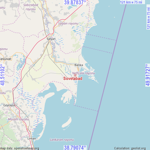
Sovetabad GPS coordinates[2]
39° 20' 12.012" North, 49° 12' 50.904" East
| Map corner | latitude | longitude |
|---|---|---|
| Upper-left | 39.87837°, | 48.51102° |
| Center: | 39.33667°, | 49.21414° |
| Lower-right: | 38.79074°, | 49.91727° |
| Map W x H: | 120.9×120.9 km | = 75.1×75.1mi |
| max Lat: | 41.75259° ⇑88.6% North |
| Sovetabad: | 39.33667° |
| min Lat: | ⇓11.4% South 38.45598° |
| min Long | Sovetabad | max Long |
| 44.84846° | 49.21414° | 50.84003° |
| W 75.7%⇐ | ⇒24.3% E |
Elevation
Elevation of Sovetabad is -25 m = -82 ft, and this is 408 m = 1339 ft below average elevation for this country.
| Max E: |
2211 m = 7254 ft | 99.5% |
| Avg. | 383 m = 1257 ft | |
| Sovetabad | -25 m = -82 ft | |
Min E: |
-26 m = -85 ft | 0.5% |
See also: Azerbaijan elevation on elevation.city.
Geographical zone
Sovetabad is located in North temperate zone (between Tropic of Cancer and the Arctic Circle). Distance of this Northern Tropic circle is 1767.9 km =1098.5 mi to South.| Distance of | km | miles | from Sovetabad |
|---|---|---|---|
| North Pole | 5633.2 | 3500.3 | to North |
| Arctic Circle | 3027.3 | 1881.1 | to North |
| Tropic Cancer | 1767.9 | 1098.5 | to South |
| Equator | 4373.8 | 2717.8 | to South |


Nearby cities:
15 places around Sovetabad: (largest is in red/bold)
• Boradigah
62.8 km =39 mi,  223°
223°
• Hacıqabul
81.4 km =50.6 mi,  343°
343°
• Haftoni
74.8 km =46.5 mi,  211°
211°
• Jalilabad
63.8 km =39.6 mi,  257°
257°
• Lankaran
72 km =44.7 mi, 205°
• Masally
58 km =36 mi,  234°
234°
• Neftçala
5.3 km =3.3 mi,  32°
32°
• Prishibinskoye
58.6 km =36.4 mi,  245°
245°
• Pushkino
59.1 km =36.7 mi,  283°
283°
• Qaraçala
58.3 km =36.2 mi, 336°
• Qobustan
84.6 km =52.6 mi,  11°
11°
• Salyan
34.9 km =21.7 mi,  325°
325°
• Severo-Vostotchnyi Bank
8.8 km =5.5 mi,  19°
19°
• Xıllı
14.2 km =8.8 mi,  317°
317°
• Şirvan
71.2 km =44.2 mi, 339°
Sources, notices
• [Note1] Compared only with cities in Azerbaijan existing in our database
• [Src1] Map data: © OpenStreetMap contributors (CC-BY-SA)
• [Src2] Other city data from geonames.org with taken over terms of usage.
• [Src3] Geographical zone / Annual Mean Temperature by Robert A. Rohde @ Wikipedia
