Astara geodata
Astara is a seat of a first-order administrative division; located in Azerbaijan in Asia/Baku (GMT+4) time zone. With population of 15,190 people, there are 55 cities with bigger population in this country. Compared to other cities in Azerbaijan, 100% of cities are located further ↑North; 69.2% of cities are located further ←West and 96.8% of cities have higher elevation than Astara. Note1


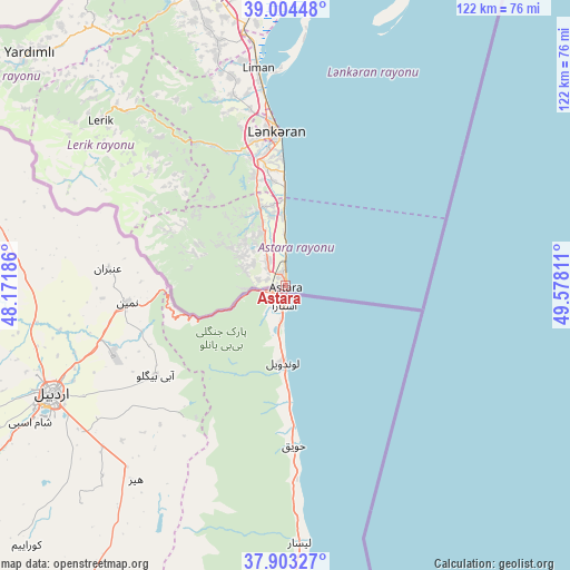
Astara GPS coordinates[2]
38° 27' 21.528" North, 48° 52' 29.928" East
| Map corner | latitude | longitude |
|---|---|---|
| Upper-left | 39.00448°, | 48.17186° |
| Center: | 38.45598°, | 48.87498° |
| Lower-right: | 37.90327°, | 49.57811° |
| Map W x H: | 122.4×122.4 km | = 76.1×76.1mi |
| max Lat: | 41.75259° ⇑100% North |
| Astara: | 38.45598° |
| min Lat: | ⇓0% South 38.45598° |
| min Long | Astara | max Long |
| 44.84846° | 48.87498° | 50.84003° |
| W 69.2%⇐ | ⇒30.8% E |
Elevation
Elevation of Astara is -22 m = -72 ft, and this is 405 m = 1329 ft below average elevation for this country.
| Max E: |
2211 m = 7254 ft | 96.8% |
| Avg. | 383 m = 1257 ft | |
| Astara | -22 m = -72 ft | |
Min E: |
-26 m = -85 ft | 3.2% |
See also: Azerbaijan elevation on elevation.city.
Geographical zone
Astara is located in North temperate zone (between Tropic of Cancer and the Arctic Circle). Distance of this Northern Tropic circle is 1670 km =1037.7 mi to South.| Distance of | km | miles | from Astara |
|---|---|---|---|
| North Pole | 5731.2 | 3561.2 | to North |
| Arctic Circle | 3125.3 | 1942 | to North |
| Tropic Cancer | 1670 | 1037.7 | to South |
| Equator | 4275.9 | 2656.9 | to South |


Nearby cities:
15 places around Astara: (largest is in red/bold)
• Boradigah
54.6 km =33.9 mi,  344°
344°
• Haftoni
35.5 km =22.1 mi, 344°
• Jalilabad
90.1 km =56 mi, 338°
• Kizhaba
10.6 km =6.6 mi,  325°
325°
• Lankaran
33.2 km =20.6 mi,  356°
356°
• Lerik
53.4 km =33.2 mi,  311°
311°
• Masally
66.9 km =41.6 mi, 344°
• Neftçala
107.3 km =66.7 mi,  17°
17°
• Prishibinskoye
77.7 km =48.3 mi, 341°
• Pushkino
115 km =71.5 mi,  345°
345°
• Salyan
127.1 km =79 mi,  4°
4°
• Severo-Vostotchnyi Bank
111 km =69 mi, 16°
• Sovetabad
102.2 km =63.5 mi, 16°
• Xıllı
110.1 km =68.4 mi,  10°
10°
• Yardımlı
74.5 km =46.3 mi, 312°
Sources, notices
• [Note1] Compared only with cities in Azerbaijan existing in our database
• [Src1] Map data: © OpenStreetMap contributors (CC-BY-SA)
• [Src2] Other city data from geonames.org with taken over terms of usage.
• [Src3] Geographical zone / Annual Mean Temperature by Robert A. Rohde @ Wikipedia
