Tovuz geodata
Tovuz is a seat of a first-order administrative division; located in Azerbaijan in Asia/Baku (GMT+4) time zone. With population of 12,626 people, there are 62 cities with bigger population in this country. Compared to other cities in Azerbaijan, 84.9% of cities are located further ↓South; 90.3% of cities are located further →East and 64.9% of cities have lower elevation than Tovuz. Note1


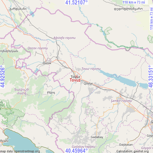
Tovuz GPS coordinates[2]
40° 59' 32.964" North, 45° 37' 42.168" East
| Map corner | latitude | longitude |
|---|---|---|
| Upper-left | 41.52107°, | 44.92526° |
| Center: | 40.99249°, | 45.62838° |
| Lower-right: | 40.45964°, | 46.33151° |
| Map W x H: | 118×118 km | = 73.3×73.3mi |
| max Lat: | 41.75259° ⇑15.1% North |
| Tovuz: | 40.99249° |
| min Lat: | ⇓84.9% South 38.45598° |
| min Long | Tovuz | max Long |
| 44.84846° | 45.62838° | 50.84003° |
| W 9.7%⇐ | ⇒90.3% E |
Elevation
Elevation of Tovuz is 421 m = 1381 ft, and this is 38 m = 125 ft above average elevation for this country.
| Max E: |
2211 m = 7254 ft | 35.1% |
| Tovuz | 421 m 1381 ft | |
| Avg. | 383 m = 1257 ft | |
Min E: |
-26 m = -85 ft | 64.9% |
See also: Azerbaijan elevation on elevation.city.
Geographical zone
Tovuz is located in North temperate zone (between Tropic of Cancer and the Arctic Circle). Distance of this Northern Tropic circle is 1952 km =1212.9 mi to South.| Distance of | km | miles | from Tovuz |
|---|---|---|---|
| North Pole | 5449.1 | 3385.9 | to North |
| Arctic Circle | 2843.2 | 1766.7 | to North |
| Tropic Cancer | 1952 | 1212.9 | to South |
| Equator | 4557.9 | 2832.1 | to South |


Nearby cities:
15 places around Tovuz: (largest is in red/bold)
• Aghstafa
20.3 km =12.6 mi,  313°
313°
• Arıqdam
46.7 km =29 mi,  162°
162°
• Böyük Qaramurad
46.3 km =28.8 mi,  179°
179°
• Dolyar
37.1 km =23.1 mi,  112°
112°
• Dondar Quşçu
4.4 km =2.7 mi,  189°
189°
• Dzagam
23.8 km =14.8 mi, 114°
• Novosaratovka
43.9 km =27.3 mi, 183°
• Qaraxanlı
6.1 km =3.8 mi,  21°
21°
• Qazax
24.7 km =15.3 mi,  296°
296°
• Saloğlu
39 km =24.2 mi,  323°
323°
• Shamkhor
37.4 km =23.2 mi,  118°
118°
• Vurğun
17.4 km =10.8 mi, 310°
• Yanıqlı
17.2 km =10.7 mi,  165°
165°
• Çatax
30.2 km =18.8 mi, 191°
• Çobansığnaq
27.5 km =17.1 mi, 166°
Sources, notices
• [Note1] Compared only with cities in Azerbaijan existing in our database
• [Src1] Map data: © OpenStreetMap contributors (CC-BY-SA)
• [Src2] Other city data from geonames.org with taken over terms of usage.
• [Src3] Geographical zone / Annual Mean Temperature by Robert A. Rohde @ Wikipedia
