Aghstafa geodata
Aghstafa (Ağstafa) is a seat of a first-order administrative division; located in Azerbaijan in Asia/Baku (GMT+4) time zone. With population of 12,542 people, there are 63 cities with bigger population in this country. Compared to other cities in Azerbaijan, 88.1% of cities are located further ↓South; 94.1% of cities are located further →East and 57.8% of cities have lower elevation than Aghstafa. Note1


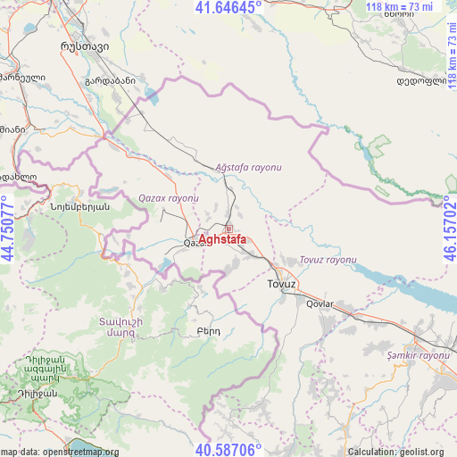
Aghstafa GPS coordinates[2]
41° 7' 8.004" North, 45° 27' 14.004" East
| Map corner | latitude | longitude |
|---|---|---|
| Upper-left | 41.64645°, | 44.75077° |
| Center: | 41.11889°, | 45.45389° |
| Lower-right: | 40.58706°, | 46.15702° |
| Map W x H: | 117.8×117.8 km | = 73.2×73.2mi |
| max Lat: | 41.75259° ⇑11.9% North |
| Aghstafa: | 41.11889° |
| min Lat: | ⇓88.1% South 38.45598° |
| min Long | Aghstafa | max Long |
| 44.84846° | 45.45389° | 50.84003° |
| W 5.9%⇐ | ⇒94.1% E |
Elevation
Elevation of Aghstafa is 327 m = 1073 ft, and this is 56 m = 184 ft below average elevation for this country.
| Max E: |
2211 m = 7254 ft | 42.2% |
| Avg. | 383 m = 1257 ft | |
| Aghstafa | 327 m = 1073 ft | |
Min E: |
-26 m = -85 ft | 57.8% |
See also: Azerbaijan elevation on elevation.city.
Geographical zone
Aghstafa is located in North temperate zone (between Tropic of Cancer and the Arctic Circle). Distance of this Northern Tropic circle is 1966.1 km =1221.7 mi to South.| Distance of | km | miles | from Aghstafa |
|---|---|---|---|
| North Pole | 5435.1 | 3377.2 | to North |
| Arctic Circle | 2829.2 | 1758 | to North |
| Tropic Cancer | 1966.1 | 1221.7 | to South |
| Equator | 4572 | 2840.9 | to South |


Nearby cities:
15 places around Aghstafa: (largest is in red/bold)
• Arıqdam
65.3 km =40.6 mi,  153°
153°
• Böyük Qaramurad
62.3 km =38.7 mi,  165°
165°
• Dolyar
56.5 km =35.1 mi,  120°
120°
• Dondar Quşçu
23 km =14.3 mi,  142°
142°
• Dzagam
43.4 km =27 mi, 123°
• Novosaratovka
59.2 km =36.8 mi, 167°
• Qaraxanlı
18.8 km =11.7 mi, 116°
• Qazax
8 km =5 mi,  248°
248°
• Saloğlu
19.3 km =12 mi,  334°
334°
• Shamkhor
57.2 km =35.5 mi, 124°
• Tovuz
20.3 km =12.6 mi,  133°
133°
• Vurğun
3 km =1.9 mi, 151°
• Yanıqlı
36.1 km =22.4 mi, 148°
• Çatax
44.5 km =27.7 mi, 168°
• Çobansığnaq
45.9 km =28.5 mi, 152°
Sources, notices
• [Note1] Compared only with cities in Azerbaijan existing in our database
• [Src1] Map data: © OpenStreetMap contributors (CC-BY-SA)
• [Src2] Other city data from geonames.org with taken over terms of usage.
• [Src3] Geographical zone / Annual Mean Temperature by Robert A. Rohde @ Wikipedia
