Dolyar geodata
Dolyar (Şǝmkir) is a populated place; located in Azerbaijan in Asia/Baku (GMT+4) time zone. With population of 4,399 people, there are 113 cities with bigger population in this country. Compared to other cities in Azerbaijan, 81.1% of cities are located further ↓South; 81.1% of cities are located further →East and 59.5% of cities have lower elevation than Dolyar. Note1


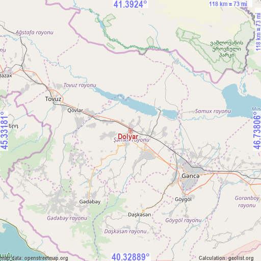
Dolyar GPS coordinates[2]
40° 51' 46.008" North, 46° 2' 5.748" East
| Map corner | latitude | longitude |
|---|---|---|
| Upper-left | 41.3924°, | 45.33181° |
| Center: | 40.86278°, | 46.03493° |
| Lower-right: | 40.32889°, | 46.73806° |
| Map W x H: | 118.3×118.3 km | = 73.5×73.5mi |
| max Lat: | 41.75259° ⇑18.9% North |
| Dolyar: | 40.86278° |
| min Lat: | ⇓81.1% South 38.45598° |
| min Long | Dolyar | max Long |
| 44.84846° | 46.03493° | 50.84003° |
| W 18.9%⇐ | ⇒81.1% E |
Elevation
Elevation of Dolyar is 341 m = 1119 ft, and this is 42 m = 138 ft below average elevation for this country.
| Max E: |
2211 m = 7254 ft | 40.5% |
| Avg. | 383 m = 1257 ft | |
| Dolyar | 341 m = 1119 ft | |
Min E: |
-26 m = -85 ft | 59.5% |
See also: Azerbaijan elevation on elevation.city.
Geographical zone
Dolyar is located in North temperate zone (between Tropic of Cancer and the Arctic Circle). Distance of this Northern Tropic circle is 1937.6 km =1204 mi to South.| Distance of | km | miles | from Dolyar |
|---|---|---|---|
| North Pole | 5463.5 | 3394.9 | to North |
| Arctic Circle | 2857.7 | 1775.7 | to North |
| Tropic Cancer | 1937.6 | 1204 | to South |
| Equator | 4543.5 | 2823.2 | to South |


Nearby cities:
15 places around Dolyar: (largest is in red/bold)
• Alunitdağ
37.1 km =23.1 mi,  177°
177°
• Arıqdam
36 km =22.4 mi,  213°
213°
• Dondar Quşçu
36.4 km =22.6 mi,  286°
286°
• Dzagam
13.3 km =8.3 mi, 289°
• Ganja
33.9 km =21.1 mi,  126°
126°
• Kyadabek
37.5 km =23.3 mi, 210°
• Qaraxanlı
37.7 km =23.4 mi,  302°
302°
• Qarayeri
24.9 km =15.5 mi,  109°
109°
• Qasım İsmayılov
19.7 km =12.2 mi, 106°
• Qırmızı Samux
30.1 km =18.7 mi,  73°
73°
• Samux
33.3 km =20.7 mi, 109°
• Shamkhor
3.9 km =2.4 mi,  201°
201°
• Tovuz
37.1 km =23.1 mi, 292°
• Yanıqlı
29.9 km =18.6 mi,  265°
265°
• Çobansığnaq
30.2 km =18.8 mi,  246°
246°
Sources, notices
• [Note1] Compared only with cities in Azerbaijan existing in our database
• [Src1] Map data: © OpenStreetMap contributors (CC-BY-SA)
• [Src2] Other city data from geonames.org with taken over terms of usage.
• [Src3] Geographical zone / Annual Mean Temperature by Robert A. Rohde @ Wikipedia
