Hacı Zeynalabdin geodata
Hacı Zeynalabdin (Sumqayit) is a populated place; located in Azerbaijan in Asia/Baku (GMT+4) time zone. With population of 19,019 people, there are 40 cities with bigger population in this country. Compared to other cities in Azerbaijan, 70.8% of cities are located further ↓South; 79.5% of cities are located further ←West and 92.4% of cities have higher elevation than Hacı Zeynalabdin. Note1


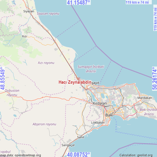
Hacı Zeynalabdin GPS coordinates[2]
40° 37' 23.988" North, 49° 33' 30.996" East
| Map corner | latitude | longitude |
|---|---|---|
| Upper-left | 41.15487°, | 48.85549° |
| Center: | 40.62333°, | 49.55861° |
| Lower-right: | 40.08752°, | 50.26174° |
| Map W x H: | 118.7×118.7 km | = 73.8×73.8mi |
| max Lat: | 41.75259° ⇑29.2% North |
| Hacı Zeynalabdin: | 40.62333° |
| min Lat: | ⇓70.8% South 38.45598° |
| min Long | Hacı Zeynalabd | max Long |
| 44.84846° | 49.55861° | 50.84003° |
| W 79.5%⇐ | ⇒20.5% E |
Elevation
Elevation of Hacı Zeynalabdin is -17 m = -56 ft, and this is 400 m = 1312 ft below average elevation for this country.
| Max E: |
2211 m = 7254 ft | 92.4% |
| Avg. | 383 m = 1257 ft | |
| Hacı Zeynalabdin | -17 m = -56 ft | |
Min E: |
-26 m = -85 ft | 7.6% |
See also: Azerbaijan elevation on elevation.city.
Geographical zone
Hacı Zeynalabdin is located in North temperate zone (between Tropic of Cancer and the Arctic Circle). Distance of this Northern Tropic circle is 1911 km =1187.4 mi to South.| Distance of | km | miles | from Hacı Zeynalabdin |
|---|---|---|---|
| North Pole | 5490.2 | 3411.5 | to North |
| Arctic Circle | 2884.3 | 1792.2 | to North |
| Tropic Cancer | 1911 | 1187.4 | to South |
| Equator | 4516.9 | 2806.7 | to South |


Nearby cities:
15 places around Hacı Zeynalabdin: (largest is in red/bold)
• Balakhani
35.3 km =21.9 mi,  120°
120°
• Bilajari
28.8 km =17.9 mi,  133°
133°
• Binagadi
28.7 km =17.8 mi, 127°
• Ceyranbatan
12.5 km =7.8 mi,  136°
136°
• Corat
13.6 km =8.5 mi,  114°
114°
• Digah
30.4 km =18.9 mi, 118°
• Gyuzdek
29.6 km =18.4 mi,  159°
159°
• Khirdalan
25.6 km =15.9 mi, 139°
• Khodzhi-Gasan
29.4 km =18.3 mi, 142°
• Kilyazi
33.2 km =20.6 mi,  326°
326°
• Qobu
27.6 km =17.1 mi,  151°
151°
• Saray
16.7 km =10.4 mi, 126°
• Sumqayıt
10 km =6.2 mi, 111°
• Şonqar
33.7 km =20.9 mi,  174°
174°
• Şuraabad
23.2 km =14.4 mi,  340°
340°
Sources, notices
• [Note1] Compared only with cities in Azerbaijan existing in our database
• [Src1] Map data: © OpenStreetMap contributors (CC-BY-SA)
• [Src2] Other city data from geonames.org with taken over terms of usage.
• [Src3] Geographical zone / Annual Mean Temperature by Robert A. Rohde @ Wikipedia
