Sumqayıt geodata
Sumqayıt (Sumqayit) is a seat of a first-order administrative division; located in Azerbaijan in Asia/Baku (GMT+4) time zone. With population of 265,150 people, there are 2 cities with bigger population in this country. Compared to other cities in Azerbaijan, 67.6% of cities are located further ↓South; 82.2% of cities are located further ←West and 87% of cities have higher elevation than Sumqayıt. Note1


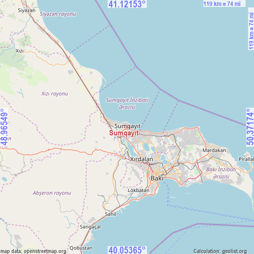
Sumqayıt GPS coordinates[2]
40° 35' 22.992" North, 49° 40' 6.996" East
| Map corner | latitude | longitude |
|---|---|---|
| Upper-left | 41.12153°, | 48.96549° |
| Center: | 40.58972°, | 49.66861° |
| Lower-right: | 40.05365°, | 50.37174° |
| Map W x H: | 118.7×118.7 km | = 73.8×73.8mi |
| max Lat: | 41.75259° ⇑32.4% North |
| Sumqayıt: | 40.58972° |
| min Lat: | ⇓67.6% South 38.45598° |
| min Long | Sumqayıt | max Long |
| 44.84846° | 49.66861° | 50.84003° |
| W 82.2%⇐ | ⇒17.8% E |
Elevation
Elevation of Sumqayıt is -11 m = -36 ft, and this is 394 m = 1293 ft below average elevation for this country.
| Max E: |
2211 m = 7254 ft | 87% |
| Avg. | 383 m = 1257 ft | |
| Sumqayıt | -11 m = -36 ft | |
Min E: |
-26 m = -85 ft | 13% |
See also: Sumqayıt elevation on elevation.city.
Geographical zone
Sumqayıt is located in North temperate zone (between Tropic of Cancer and the Arctic Circle). Distance of this Northern Tropic circle is 1907.2 km =1185.1 mi to South.| Distance of | km | miles | from Sumqayıt |
|---|---|---|---|
| North Pole | 5493.9 | 3413.8 | to North |
| Arctic Circle | 2888 | 1794.5 | to North |
| Tropic Cancer | 1907.2 | 1185.1 | to South |
| Equator | 4513.2 | 2804.4 | to South |


Nearby cities:
15 places around Sumqayıt: (largest is in red/bold)
• Balakhani
25.4 km =15.8 mi,  123°
123°
• Bilajari
19.9 km =12.4 mi,  144°
144°
• Binagadi
19.2 km =11.9 mi, 135°
• Ceyranbatan
5.4 km =3.4 mi,  187°
187°
• Corat
3.7 km =2.3 mi, 122°
• Digah
20.5 km =12.7 mi, 121°
• Gyuzdek
24 km =14.9 mi,  177°
177°
• Hacı Zeynalabdin
10 km =6.2 mi,  291°
291°
• Khirdalan
17.4 km =10.8 mi,  155°
155°
• Khodzhi-Gasan
21.4 km =13.3 mi, 156°
• Nardaran
28.7 km =17.8 mi,  97°
97°
• Qobu
20.9 km =13 mi,  169°
169°
• Sabunçu
28.7 km =17.8 mi, 124°
• Saray
7.5 km =4.7 mi,  147°
147°
• Zabrat
26.2 km =16.3 mi, 118°
Sources, notices
• [Note1] Compared only with cities in Azerbaijan existing in our database
• [Src1] Map data: © OpenStreetMap contributors (CC-BY-SA)
• [Src2] Other city data from geonames.org with taken over terms of usage.
• [Src3] Geographical zone / Annual Mean Temperature by Robert A. Rohde @ Wikipedia
