Qasım İsmayılov geodata
Qasım İsmayılov (Şǝmkir) is a populated place; located in Azerbaijan in Asia/Baku (GMT+4) time zone. With population of 1,925 people, there are 149 cities with bigger population in this country. Compared to other cities in Azerbaijan, 77.8% of cities are located further ↓South; 78.4% of cities are located further →East and 51.9% of cities have lower elevation than Qasım İsmayılov. Note1


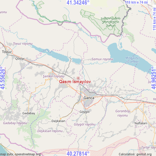
Qasım İsmayılov GPS coordinates[2]
40° 48' 44.748" North, 46° 15' 33.768" East
| Map corner | latitude | longitude |
|---|---|---|
| Upper-left | 41.34246°, | 45.55626° |
| Center: | 40.81243°, | 46.25938° |
| Lower-right: | 40.27814°, | 46.96251° |
| Map W x H: | 118.3×118.3 km | = 73.5×73.5mi |
| max Lat: | 41.75259° ⇑22.2% North |
| Qasım İsmayılov: | 40.81243° |
| min Lat: | ⇓77.8% South 38.45598° |
| min Long | Qasım İsmayı | max Long |
| 44.84846° | 46.25938° | 50.84003° |
| W 21.6%⇐ | ⇒78.4% E |
Elevation
Elevation of Qasım İsmayılov is 228 m = 748 ft, and this is 155 m = 509 ft below average elevation for this country.
| Max E: |
2211 m = 7254 ft | 48.1% |
| Avg. | 383 m = 1257 ft | |
| Qasım İsmayılov | 228 m = 748 ft | |
Min E: |
-26 m = -85 ft | 51.9% |
See also: Azerbaijan elevation on elevation.city.
Geographical zone
Qasım İsmayılov is located in North temperate zone (between Tropic of Cancer and the Arctic Circle). Distance of this Northern Tropic circle is 1932 km =1200.5 mi to South.| Distance of | km | miles | from Qasım İsmayılov |
|---|---|---|---|
| North Pole | 5469.1 | 3398.3 | to North |
| Arctic Circle | 2863.3 | 1779.2 | to North |
| Tropic Cancer | 1932 | 1200.5 | to South |
| Equator | 4537.9 | 2819.7 | to South |


Nearby cities:
15 places around Qasım İsmayılov: (largest is in red/bold)
• Alunitdağ
36 km =22.4 mi,  209°
209°
• Arıqdam
45.8 km =28.5 mi,  237°
237°
• Dolyar
19.7 km =12.2 mi,  286°
286°
• Dzagam
33 km =20.5 mi, 287°
• Ganja
16.7 km =10.4 mi,  149°
149°
• Kyadabek
46.3 km =28.8 mi,  234°
234°
• Qarayeri
5.4 km =3.4 mi,  122°
122°
• Qazanbulaq
39.3 km =24.4 mi, 123°
• Qırmızı Samux
17.4 km =10.8 mi,  35°
35°
• Samux
13.6 km =8.5 mi,  112°
112°
• Shamkhor
20.4 km =12.7 mi,  275°
275°
• Verkhniy Dashkesan
38.8 km =24.1 mi,  204°
204°
• Yelenendorf
25.7 km =16 mi,  168°
168°
• Yukhary-Dashkesan
35.4 km =22 mi, 205°
• Çobansığnaq
47 km =29.2 mi,  261°
261°
Sources, notices
• [Note1] Compared only with cities in Azerbaijan existing in our database
• [Src1] Map data: © OpenStreetMap contributors (CC-BY-SA)
• [Src2] Other city data from geonames.org with taken over terms of usage.
• [Src3] Geographical zone / Annual Mean Temperature by Robert A. Rohde @ Wikipedia
