Qırmızı Samux geodata
Qırmızı Samux (Samux) is a populated place; located in Azerbaijan in Asia/Baku (GMT+4) time zone. With population of 2,319 people, there are 139 cities with bigger population in this country. Compared to other cities in Azerbaijan, 83.2% of cities are located further ↓South; 75.7% of cities are located further →East and 54.1% of cities have higher elevation than Qırmızı Samux. Note1


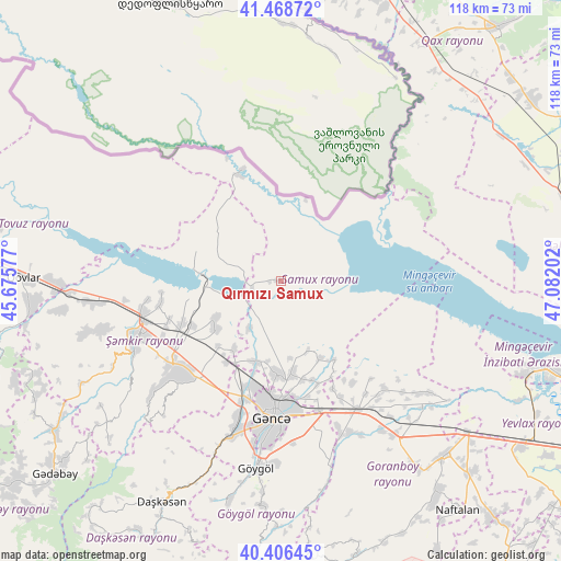
Qırmızı Samux GPS coordinates[2]
40° 56' 22.992" North, 46° 22' 44.004" East
| Map corner | latitude | longitude |
|---|---|---|
| Upper-left | 41.46872°, | 45.67577° |
| Center: | 40.93972°, | 46.37889° |
| Lower-right: | 40.40645°, | 47.08202° |
| Map W x H: | 118.1×118.1 km | = 73.4×73.4mi |
| max Lat: | 41.75259° ⇑16.8% North |
| Qırmızı Samux: | 40.93972° |
| min Lat: | ⇓83.2% South 38.45598° |
| min Long | Qırmızı Samu | max Long |
| 44.84846° | 46.37889° | 50.84003° |
| W 24.3%⇐ | ⇒75.7% E |
Elevation
Elevation of Qırmızı Samux is 99 m = 325 ft, and this is 284 m = 932 ft below average elevation for this country.
| Max E: |
2211 m = 7254 ft | 54.1% |
| Avg. | 383 m = 1257 ft | |
| Qırmızı Samux | 99 m = 325 ft | |
Min E: |
-26 m = -85 ft | 45.9% |
See also: Azerbaijan elevation on elevation.city.
Geographical zone
Qırmızı Samux is located in North temperate zone (between Tropic of Cancer and the Arctic Circle). Distance of this Northern Tropic circle is 1946.2 km =1209.3 mi to South.| Distance of | km | miles | from Qırmızı Samux |
|---|---|---|---|
| North Pole | 5455 | 3389.6 | to North |
| Arctic Circle | 2849.1 | 1770.3 | to North |
| Tropic Cancer | 1946.2 | 1209.3 | to South |
| Equator | 4552.1 | 2828.5 | to South |


Nearby cities:
15 places around Qırmızı Samux: (largest is in red/bold)
• Alunitdağ
53.3 km =33.1 mi,  211°
211°
• Dolyar
30.1 km =18.7 mi,  253°
253°
• Dzagam
41.6 km =25.8 mi,  264°
264°
• Ganja
28.6 km =17.8 mi,  183°
183°
• Goranboy
50.4 km =31.3 mi,  136°
136°
• Qarayeri
17.9 km =11.1 mi,  197°
197°
• Qasım İsmayılov
17.4 km =10.8 mi,  215°
215°
• Qazanbulaq
42.3 km =26.3 mi,  147°
147°
• Qızılhacılı
57 km =35.4 mi,  134°
134°
• Samux
19.6 km =12.2 mi,  172°
172°
• Shamkhor
32.7 km =20.3 mi, 248°
• Verkhniy Dashkesan
56 km =34.8 mi, 207°
• Yanıqlı
59.7 km =37.1 mi, 259°
• Yelenendorf
39.7 km =24.7 mi,  187°
187°
• Yukhary-Dashkesan
52.6 km =32.7 mi, 208°
Sources, notices
• [Note1] Compared only with cities in Azerbaijan existing in our database
• [Src1] Map data: © OpenStreetMap contributors (CC-BY-SA)
• [Src2] Other city data from geonames.org with taken over terms of usage.
• [Src3] Geographical zone / Annual Mean Temperature by Robert A. Rohde @ Wikipedia
