Ganja geodata
Ganja (Gǝncǝ) is a seat of a first-order administrative division; located in Azerbaijan in Asia/Baku (GMT+4) time zone. With population of 313,300 people, there is 1 city with bigger population in this country. Compared to other cities in Azerbaijan, 73.5% of cities are located further ↓South; 76.2% of cities are located further →East and 63.2% of cities have lower elevation than Ganja. Note1


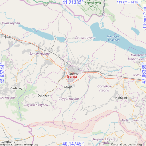
Ganja GPS coordinates[2]
40° 40' 58.008" North, 46° 21' 38.016" East
| Map corner | latitude | longitude |
|---|---|---|
| Upper-left | 41.21385°, | 45.65744° |
| Center: | 40.68278°, | 46.36056° |
| Lower-right: | 40.14745°, | 47.06369° |
| Map W x H: | 118.6×118.6 km | = 73.7×73.7mi |
| max Lat: | 41.75259° ⇑26.5% North |
| Ganja: | 40.68278° |
| min Lat: | ⇓73.5% South 38.45598° |
| min Long | Ganja | max Long |
| 44.84846° | 46.36056° | 50.84003° |
| W 23.8%⇐ | ⇒76.2% E |
Elevation
Elevation of Ganja is 417 m = 1368 ft, and this is 34 m = 112 ft above average elevation for this country.
| Max E: |
2211 m = 7254 ft | 36.8% |
| Ganja | 417 m 1368 ft | |
| Avg. | 383 m = 1257 ft | |
Min E: |
-26 m = -85 ft | 63.2% |
See also: Ganja elevation on elevation.city.
Geographical zone
Ganja is located in North temperate zone (between Tropic of Cancer and the Arctic Circle). Distance of this Northern Tropic circle is 1917.6 km =1191.5 mi to South.| Distance of | km | miles | from Ganja |
|---|---|---|---|
| North Pole | 5483.6 | 3407.4 | to North |
| Arctic Circle | 2877.7 | 1788.1 | to North |
| Tropic Cancer | 1917.6 | 1191.5 | to South |
| Equator | 4523.5 | 2810.8 | to South |


Nearby cities:
15 places around Ganja: (largest is in red/bold)
• Alunitdağ
31.1 km =19.3 mi,  236°
236°
• Dolyar
33.9 km =21.1 mi,  306°
306°
• Dzagam
46.9 km =29.1 mi,  301°
301°
• Goranboy
37.1 km =23.1 mi,  102°
102°
• Naftalan
43.4 km =27 mi,  116°
116°
• Qarayeri
12.2 km =7.6 mi,  341°
341°
• Qasım İsmayılov
16.7 km =10.4 mi,  329°
329°
• Qazanbulaq
25.4 km =15.8 mi,  106°
106°
• Qırmızı Samux
28.6 km =17.8 mi,  3°
3°
• Qızılhacılı
43.6 km =27.1 mi, 105°
• Samux
10 km =6.2 mi,  23°
23°
• Shamkhor
33.2 km =20.6 mi, 299°
• Verkhniy Dashkesan
32.2 km =20 mi,  229°
229°
• Yelenendorf
11.3 km =7 mi,  198°
198°
• Yukhary-Dashkesan
29.4 km =18.3 mi, 233°
In other languages:
- In Spanish: Gandja
- In France: Gandja
- In German: Gäncä
- In Italian: Gäncä
- In Russian: Гянджа
- In Chinese: 占贾
Sources, notices
• [Note1] Compared only with cities in Azerbaijan existing in our database
• [Src1] Map data: © OpenStreetMap contributors (CC-BY-SA)
• [Src2] Other city data from geonames.org with taken over terms of usage.
• [Src3] Geographical zone / Annual Mean Temperature by Robert A. Rohde @ Wikipedia
