Martakert geodata
Martakert (Tǝrtǝr) is a populated place; located in Azerbaijan in Asia/Baku (GMT+4) time zone. With population of 10,167 people, there are 71 cities with bigger population in this country. Compared to other cities in Azerbaijan, 63.2% of cities are located further ↑North; 65.4% of cities are located further →East and 65.4% of cities have lower elevation than Martakert. Note1


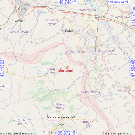
Martakert GPS coordinates[2]
40° 12' 40.572" North, 46° 49' 16.86" East
| Map corner | latitude | longitude |
|---|---|---|
| Upper-left | 40.7461°, | 46.11823° |
| Center: | 40.21127°, | 46.82135° |
| Lower-right: | 39.67219°, | 47.52448° |
| Map W x H: | 119.4×119.4 km | = 74.2×74.2mi |
| max Lat: | 41.75259° ⇑63.2% North |
| Martakert: | 40.21127° |
| min Lat: | ⇓36.8% South 38.45598° |
| min Long | Martakert | max Long |
| 44.84846° | 46.82135° | 50.84003° |
| W 34.6%⇐ | ⇒65.4% E |
Elevation
Elevation of Martakert is 438 m = 1437 ft, and this is 55 m = 180 ft above average elevation for this country.
| Max E: |
2211 m = 7254 ft | 34.6% |
| Martakert | 438 m 1437 ft | |
| Avg. | 383 m = 1257 ft | |
Min E: |
-26 m = -85 ft | 65.4% |
See also: Azerbaijan elevation on elevation.city.
Geographical zone
Martakert is located in North temperate zone (between Tropic of Cancer and the Arctic Circle). Distance of this Northern Tropic circle is 1865.2 km =1159 mi to South.| Distance of | km | miles | from Martakert |
|---|---|---|---|
| North Pole | 5536 | 3439.9 | to North |
| Arctic Circle | 2930.1 | 1820.7 | to North |
| Tropic Cancer | 1865.2 | 1159 | to South |
| Equator | 4471.1 | 2778.2 | to South |


Nearby cities:
15 places around Martakert: (largest is in red/bold)
• Aran
47.8 km =29.7 mi,  15°
15°
• Askyaran
30.3 km =18.8 mi,  178°
178°
• Ağdam
26.1 km =16.2 mi,  159°
159°
• Barda
31.7 km =19.7 mi,  54°
54°
• Goranboy
44.4 km =27.6 mi,  356°
356°
• Naftalan
33 km =20.5 mi, 359°
• Qaramanlı
33.4 km =20.8 mi,  25°
25°
• Qazanbulaq
47.6 km =29.6 mi,  342°
342°
• Qızılhacılı
40.8 km =25.4 mi,  4°
4°
• Samuxlu
44.3 km =27.5 mi,  41°
41°
• Shushi
50.5 km =31.4 mi,  186°
186°
• Terter
17.3 km =10.7 mi, 32°
• Vank
29.4 km =18.3 mi,  233°
233°
• Xankandi
44.1 km =27.4 mi, 187°
• Xocalı
33.3 km =20.7 mi, 184°
Sources, notices
• [Note1] Compared only with cities in Azerbaijan existing in our database
• [Src1] Map data: © OpenStreetMap contributors (CC-BY-SA)
• [Src2] Other city data from geonames.org with taken over terms of usage.
• [Src3] Geographical zone / Annual Mean Temperature by Robert A. Rohde @ Wikipedia
