Qazanbulaq geodata
Qazanbulaq (Goranboy) is a populated place; located in Azerbaijan in Asia/Baku (GMT+4) time zone. With population of 980 people, there are 173 cities with bigger population in this country. Compared to other cities in Azerbaijan, 70.3% of cities are located further ↓South; 70.3% of cities are located further →East and 55.7% of cities have lower elevation than Qazanbulaq. Note1


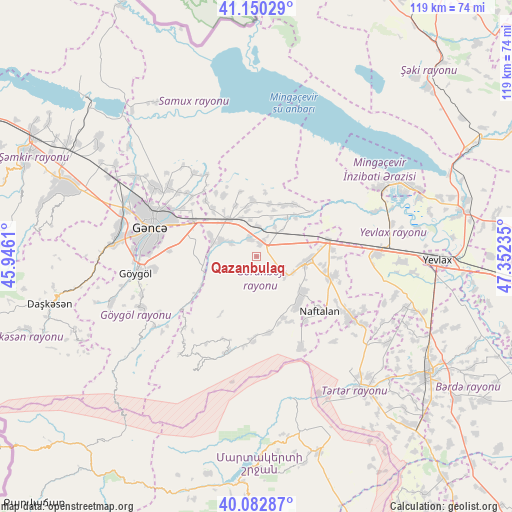
Qazanbulaq GPS coordinates[2]
40° 37' 7.356" North, 46° 38' 57.192" East
| Map corner | latitude | longitude |
|---|---|---|
| Upper-left | 41.15029°, | 45.9461° |
| Center: | 40.61871°, | 46.64922° |
| Lower-right: | 40.08287°, | 47.35235° |
| Map W x H: | 118.7×118.7 km | = 73.8×73.8mi |
| max Lat: | 41.75259° ⇑29.7% North |
| Qazanbulaq: | 40.61871° |
| min Lat: | ⇓70.3% South 38.45598° |
| min Long | Qazanbulaq | max Long |
| 44.84846° | 46.64922° | 50.84003° |
| W 29.7%⇐ | ⇒70.3% E |
Elevation
Elevation of Qazanbulaq is 259 m = 850 ft, and this is 124 m = 407 ft below average elevation for this country.
| Max E: |
2211 m = 7254 ft | 44.3% |
| Avg. | 383 m = 1257 ft | |
| Qazanbulaq | 259 m = 850 ft | |
Min E: |
-26 m = -85 ft | 55.7% |
See also: Azerbaijan elevation on elevation.city.
Geographical zone
Qazanbulaq is located in North temperate zone (between Tropic of Cancer and the Arctic Circle). Distance of this Northern Tropic circle is 1910.5 km =1187.1 mi to South.| Distance of | km | miles | from Qazanbulaq |
|---|---|---|---|
| North Pole | 5490.7 | 3411.8 | to North |
| Arctic Circle | 2884.8 | 1792.5 | to North |
| Tropic Cancer | 1910.5 | 1187.1 | to South |
| Equator | 4516.4 | 2806.4 | to South |


Nearby cities:
15 places around Qazanbulaq: (largest is in red/bold)
• Aran
27.6 km =17.1 mi,  88°
88°
• Ganja
25.4 km =15.8 mi,  286°
286°
• Goranboy
11.9 km =7.4 mi, 94°
• Mingelchaur
38.2 km =23.7 mi,  64°
64°
• Naftalan
19 km =11.8 mi,  130°
130°
• Qaramanlı
32.8 km =20.4 mi,  117°
117°
• Qarayeri
33.9 km =21.1 mi,  303°
303°
• Qasım İsmayılov
39.3 km =24.4 mi, 303°
• Qırmızı Samux
42.3 km =26.3 mi,  327°
327°
• Qızılhacılı
18.2 km =11.3 mi,  104°
104°
• Samux
26 km =16.2 mi,  308°
308°
• Samuxlu
45.7 km =28.4 mi,  105°
105°
• Terter
38.9 km =24.2 mi,  142°
142°
• Yelenendorf
28.1 km =17.5 mi,  262°
262°
• Yevlakh
42.3 km =26.3 mi, 90°
Sources, notices
• [Note1] Compared only with cities in Azerbaijan existing in our database
• [Src1] Map data: © OpenStreetMap contributors (CC-BY-SA)
• [Src2] Other city data from geonames.org with taken over terms of usage.
• [Src3] Geographical zone / Annual Mean Temperature by Robert A. Rohde @ Wikipedia
