Terter geodata
Terter (Tǝrtǝr) is a seat of a first-order administrative division; located in Azerbaijan in Asia/Baku (GMT+4) time zone. With population of 18,185 people, there are 45 cities with bigger population in this country. Compared to other cities in Azerbaijan, 58.4% of cities are located further ↑North; 62.2% of cities are located further →East and 54.1% of cities have lower elevation than Terter. Note1


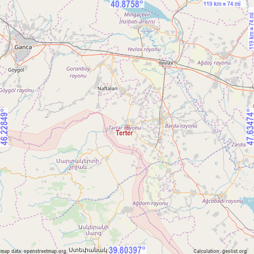
Terter GPS coordinates[2]
40° 20' 31.236" North, 46° 55' 53.796" East
| Map corner | latitude | longitude |
|---|---|---|
| Upper-left | 40.8758°, | 46.22849° |
| Center: | 40.34201°, | 46.93161° |
| Lower-right: | 39.80397°, | 47.63474° |
| Map W x H: | 119.2×119.2 km | = 74.1×74.1mi |
| max Lat: | 41.75259° ⇑58.4% North |
| Terter: | 40.34201° |
| min Lat: | ⇓41.6% South 38.45598° |
| min Long | Terter | max Long |
| 44.84846° | 46.93161° | 50.84003° |
| W 37.8%⇐ | ⇒62.2% E |
Elevation
Elevation of Terter is 254 m = 833 ft, and this is 129 m = 423 ft below average elevation for this country.
| Max E: |
2211 m = 7254 ft | 45.9% |
| Avg. | 383 m = 1257 ft | |
| Terter | 254 m = 833 ft | |
Min E: |
-26 m = -85 ft | 54.1% |
See also: Azerbaijan elevation on elevation.city.
Geographical zone
Terter is located in North temperate zone (between Tropic of Cancer and the Arctic Circle). Distance of this Northern Tropic circle is 1879.7 km =1168 mi to South.| Distance of | km | miles | from Terter |
|---|---|---|---|
| North Pole | 5521.5 | 3430.9 | to North |
| Arctic Circle | 2915.6 | 1811.7 | to North |
| Tropic Cancer | 1879.7 | 1168 | to South |
| Equator | 4485.6 | 2787.2 | to South |


Nearby cities:
15 places around Terter: (largest is in red/bold)
• Aran
31.7 km =19.7 mi,  6°
6°
• Askyaran
45.6 km =28.3 mi,  190°
190°
• Ağdam
39 km =24.2 mi,  180°
180°
• Barda
16.9 km =10.5 mi,  77°
77°
• Goranboy
32.2 km =20 mi,  338°
338°
• Martakert
17.3 km =10.7 mi,  212°
212°
• Mingelchaur
48.1 km =29.9 mi, 12°
• Naftalan
20.7 km =12.9 mi,  332°
332°
• Qaramanlı
16.4 km =10.2 mi,  18°
18°
• Qazanbulaq
38.9 km =24.2 mi,  322°
322°
• Qızılhacılı
26.9 km =16.7 mi,  346°
346°
• Samuxlu
27.3 km =17 mi,  47°
47°
• Vank
46 km =28.6 mi,  225°
225°
• Xocalı
49.2 km =30.6 mi, 194°
• Yevlakh
35.9 km =22.3 mi,  31°
31°
Sources, notices
• [Note1] Compared only with cities in Azerbaijan existing in our database
• [Src1] Map data: © OpenStreetMap contributors (CC-BY-SA)
• [Src2] Other city data from geonames.org with taken over terms of usage.
• [Src3] Geographical zone / Annual Mean Temperature by Robert A. Rohde @ Wikipedia
