Qızılhacılı geodata
Qızılhacılı (Goranboy) is a populated place; located in Azerbaijan in Asia/Baku (GMT+4) time zone. With population of 6,330 people, there are 101 cities with bigger population in this country. Compared to other cities in Azerbaijan, 66.5% of cities are located further ↓South; 64.3% of cities are located further →East and 53% of cities have higher elevation than Qızılhacılı. Note1


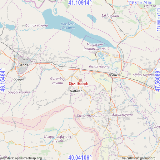
Qızılhacılı GPS coordinates[2]
40° 34' 38.028" North, 46° 51' 27.936" East
| Map corner | latitude | longitude |
|---|---|---|
| Upper-left | 41.10914°, | 46.15464° |
| Center: | 40.57723°, | 46.85776° |
| Lower-right: | 40.04106°, | 47.56089° |
| Map W x H: | 118.8×118.8 km | = 73.8×73.8mi |
| max Lat: | 41.75259° ⇑33.5% North |
| Qızılhacılı: | 40.57723° |
| min Lat: | ⇓66.5% South 38.45598° |
| min Long | Qızılhacılı | max Long |
| 44.84846° | 46.85776° | 50.84003° |
| W 35.7%⇐ | ⇒64.3% E |
Elevation
Elevation of Qızılhacılı is 122 m = 400 ft, and this is 261 m = 856 ft below average elevation for this country.
| Max E: |
2211 m = 7254 ft | 53% |
| Avg. | 383 m = 1257 ft | |
| Qızılhacılı | 122 m = 400 ft | |
Min E: |
-26 m = -85 ft | 47% |
See also: Azerbaijan elevation on elevation.city.
Geographical zone
Qızılhacılı is located in North temperate zone (between Tropic of Cancer and the Arctic Circle). Distance of this Northern Tropic circle is 1905.8 km =1184.2 mi to South.| Distance of | km | miles | from Qızılhacılı |
|---|---|---|---|
| North Pole | 5495.3 | 3414.6 | to North |
| Arctic Circle | 2889.4 | 1795.4 | to North |
| Tropic Cancer | 1905.8 | 1184.2 | to South |
| Equator | 4511.8 | 2803.5 | to South |


Nearby cities:
15 places around Qızılhacılı: (largest is in red/bold)
• Aran
11.3 km =7 mi,  61°
61°
• Barda
31.9 km =19.8 mi,  134°
134°
• Ganja
43.6 km =27.1 mi,  285°
285°
• Goranboy
6.8 km =4.2 mi,  302°
302°
• Martakert
40.8 km =25.4 mi,  184°
184°
• Mingelchaur
26.8 km =16.7 mi,  39°
39°
• Naftalan
8.3 km =5.2 mi,  202°
202°
• Qaramanlı
15.7 km =9.8 mi, 132°
• Qarayeri
51.5 km =32 mi, 296°
• Qazanbulaq
18.2 km =11.3 mi,  284°
284°
• Samux
43.2 km =26.8 mi, 298°
• Samuxlu
27.5 km =17.1 mi,  106°
106°
• Terter
26.9 km =16.7 mi,  166°
166°
• Yelenendorf
45.5 km =28.3 mi,  271°
271°
• Yevlakh
25.1 km =15.6 mi,  79°
79°
Sources, notices
• [Note1] Compared only with cities in Azerbaijan existing in our database
• [Src1] Map data: © OpenStreetMap contributors (CC-BY-SA)
• [Src2] Other city data from geonames.org with taken over terms of usage.
• [Src3] Geographical zone / Annual Mean Temperature by Robert A. Rohde @ Wikipedia
