Goranboy geodata
Goranboy is a seat of a first-order administrative division; located in Azerbaijan in Asia/Baku (GMT+4) time zone. With population of 7,333 people, there are 91 cities with bigger population in this country. Compared to other cities in Azerbaijan, 69.2% of cities are located further ↓South; 67% of cities are located further →East and 51.4% of cities have higher elevation than Goranboy. Note1


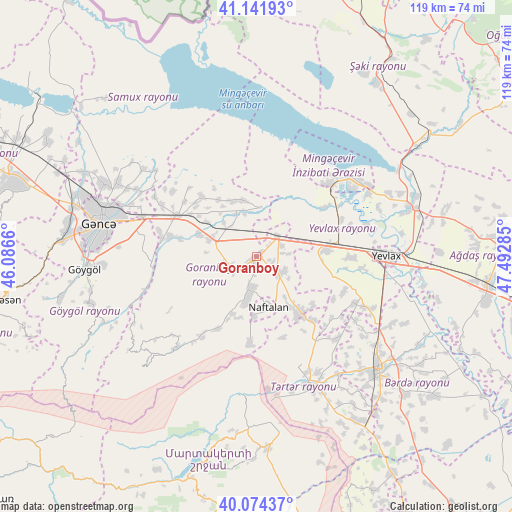
Goranboy GPS coordinates[2]
40° 36' 37.008" North, 46° 47' 22.992" East
| Map corner | latitude | longitude |
|---|---|---|
| Upper-left | 41.14193°, | 46.0866° |
| Center: | 40.61028°, | 46.78972° |
| Lower-right: | 40.07437°, | 47.49285° |
| Map W x H: | 118.7×118.7 km | = 73.8×73.8mi |
| max Lat: | 41.75259° ⇑30.8% North |
| Goranboy: | 40.61028° |
| min Lat: | ⇓69.2% South 38.45598° |
| min Long | Goranboy | max Long |
| 44.84846° | 46.78972° | 50.84003° |
| W 33%⇐ | ⇒67% E |
Elevation
Elevation of Goranboy is 156 m = 512 ft, and this is 227 m = 745 ft below average elevation for this country.
| Max E: |
2211 m = 7254 ft | 51.4% |
| Avg. | 383 m = 1257 ft | |
| Goranboy | 156 m = 512 ft | |
Min E: |
-26 m = -85 ft | 48.6% |
See also: Azerbaijan elevation on elevation.city.
Geographical zone
Goranboy is located in North temperate zone (between Tropic of Cancer and the Arctic Circle). Distance of this Northern Tropic circle is 1909.5 km =1186.5 mi to South.| Distance of | km | miles | from Goranboy |
|---|---|---|---|
| North Pole | 5491.6 | 3412.3 | to North |
| Arctic Circle | 2885.7 | 1793.1 | to North |
| Tropic Cancer | 1909.5 | 1186.5 | to South |
| Equator | 4515.4 | 2805.7 | to South |


Nearby cities:
15 places around Goranboy: (largest is in red/bold)
• Aran
15.8 km =9.8 mi,  83°
83°
• Barda
38.6 km =24 mi,  132°
132°
• Ganja
37.1 km =23.1 mi,  282°
282°
• Martakert
44.4 km =27.6 mi,  176°
176°
• Mingelchaur
28.5 km =17.7 mi,  53°
53°
• Naftalan
11.6 km =7.2 mi,  167°
167°
• Qaramanlı
22.4 km =13.9 mi, 129°
• Qarayeri
44.7 km =27.8 mi,  296°
296°
• Qazanbulaq
11.9 km =7.4 mi,  274°
274°
• Qızılhacılı
6.8 km =4.2 mi,  122°
122°
• Samux
36.4 km =22.6 mi, 298°
• Samuxlu
34.1 km =21.2 mi,  109°
109°
• Terter
32.2 km =20 mi,  158°
158°
• Yelenendorf
39.8 km =24.7 mi, 266°
• Yevlakh
30.4 km =18.9 mi,  88°
88°
Sources, notices
• [Note1] Compared only with cities in Azerbaijan existing in our database
• [Src1] Map data: © OpenStreetMap contributors (CC-BY-SA)
• [Src2] Other city data from geonames.org with taken over terms of usage.
• [Src3] Geographical zone / Annual Mean Temperature by Robert A. Rohde @ Wikipedia
