Comilla geodata
Comilla (Chittagong) is a populated place; located in Bangladesh in Asia/Dhaka (GMT+6) time zone. With population of 389,411 people, there are 4 cities with bigger population in this country. Compared to other cities in Bangladesh, 60.7% of cities are located further ↑North; 83.8% of cities are located further ←West and 62.4% of cities have lower elevation than Comilla. Note1
Administrative division(s):
- Level 1: Chittagong
- Level 2: Comilla
- Level 3: Comilla S.
- Level 4: Paurashava


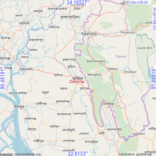
Comilla GPS coordinates[2]
23° 27' 42.696" North, 91° 11' 6.108" East
| Map corner | latitude | longitude |
|---|---|---|
| Upper-left | 24.10527°, | 90.48191° |
| Center: | 23.46186°, | 91.18503° |
| Lower-right: | 22.8153°, | 91.88816° |
| Map W x H: | 143.4×143.4 km | = 89.1×89.1mi |
| max Lat: | 26.33338° ⇑60.7% North |
| Comilla: | 23.46186° |
| min Lat: | ⇓39.3% South 20.85829° |
| min Long | Comilla | max Long |
| 88.15638° | 91.18503° | 92.29773° |
| W 83.8%⇐ | ⇒16.2% E |
Elevation
Elevation of Comilla is 17 m = 56 ft, and this is 0.9 m = 3 ft below average elevation for this country.
| Max E: |
79 m = 259 ft | 37.6% |
| Avg. | 17.9 m = 59 ft | |
| Comilla | 17 m = 56 ft | |
Min E: |
2 m = 7 ft | 62.4% |
See also: Comilla elevation on elevation.city.
Geographical zone
Comilla is located in North temperate zone (between Tropic of Cancer and the Arctic Circle). Distance of this Northern Tropic circle is 2.8 km =1.7 mi to South.| Distance of | km | miles | from Comilla |
|---|---|---|---|
| North Pole | 7398.3 | 4597.1 | to North |
| Arctic Circle | 4792.5 | 2977.9 | to North |
| Tropic Cancer | 2.8 | 1.7 | to South |
| Equator | 2608.7 | 1621 | to South |


Nearby cities:
15 places around Comilla: (largest is in red/bold)
• Azimpur
86.8 km =53.9 mi,  290°
290°
• Bhairab Bāzār
69 km =42.9 mi,  342°
342°
• Chhāgalnāiya
58.9 km =36.6 mi,  145°
145°
• Dhaka
83.9 km =52.1 mi, 289°
• Feni
54.2 km =33.7 mi,  156°
156°
• Hājīganj
41 km =25.5 mi,  235°
235°
• Lakshmīpur
68 km =42.3 mi,  212°
212°
• Lākshām
25.5 km =15.8 mi,  194°
194°
• Nabīnagar
52.3 km =32.5 mi,  334°
334°
• Narsingdi
70 km =43.5 mi,  317°
317°
• Nārāyanganj
71.5 km =44.4 mi,  283°
283°
• Paltan
84.3 km =52.4 mi, 291°
• Rāipur
63.4 km =39.4 mi,  222°
222°
• Rāmganj
52.8 km =32.8 mi, 220°
• Sonārgaon
61.6 km =38.3 mi, 289°
Sources, notices
• [Note1] Compared only with cities in Bangladesh existing in our database
• [Src1] Map data: © OpenStreetMap contributors (CC-BY-SA)
• [Src2] Other city data from geonames.org with taken over terms of usage.
• [Src3] Geographical zone / Annual Mean Temperature by Robert A. Rohde @ Wikipedia
