Lakshmīpur geodata
Lakshmīpur (Chittagong) is a populated place; located in Bangladesh in Asia/Dhaka (GMT+6) time zone. With population of 61,703 people, there are 53 cities with bigger population in this country. Compared to other cities in Bangladesh, 76.1% of cities are located further ↑North; 77.8% of cities are located further ←West and 76.1% of cities have higher elevation than Lakshmīpur. Note1
Administrative division(s):
- Level 1: Chittagong
- Level 2: Lakshmipur
- Level 3: Lakshmipur Sadar Upazila
- Level 4: Paurashava


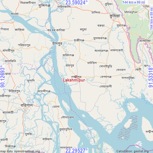
Lakshmīpur GPS coordinates[2]
22° 56' 39.48" North, 90° 49' 48.18" East
| Map corner | latitude | longitude |
|---|---|---|
| Upper-left | 23.59024°, | 90.12693° |
| Center: | 22.9443°, | 90.83005° |
| Lower-right: | 22.29527°, | 91.53318° |
| Map W x H: | 144×144 km | = 89.5×89.5mi |
| max Lat: | 26.33338° ⇑76.1% North |
| Lakshmīpur: | 22.9443° |
| min Lat: | ⇓23.9% South 20.85829° |
| min Long | Lakshmīpur | max Long |
| 88.15638° | 90.83005° | 92.29773° |
| W 77.8%⇐ | ⇒22.2% E |
Elevation
Elevation of Lakshmīpur is 11 m = 36 ft, and this is 6.9 m = 23 ft below average elevation for this country.
| Max E: |
79 m = 259 ft | 76.1% |
| Avg. | 17.9 m = 59 ft | |
| Lakshmīpur | 11 m = 36 ft | |
Min E: |
2 m = 7 ft | 23.9% |
See also: Lakshmīpur elevation on elevation.city.
Geographical zone
Lakshmīpur is located in North Torrid zone (between Equator and Tropic of Cancer). Distance of this Northern Tropic circle is 54.8 km =34.1 mi to North.| Distance of | km | miles | from Lakshmīpur |
|---|---|---|---|
| North Pole | 7455.9 | 4632.9 | to North |
| Arctic Circle | 4850 | 3013.6 | to North |
| Tropic Cancer | 54.8 | 34.1 | to North |
| Equator | 2551.2 | 1585.2 | to South |


Nearby cities:
15 places around Lakshmīpur: (largest is in red/bold)
• Barisāl
54.1 km =33.6 mi,  240°
240°
• Bhola
34.3 km =21.3 mi,  213°
213°
• Burhānuddin
51.1 km =31.8 mi,  192°
192°
• Comilla
68 km =42.3 mi,  32°
32°
• Feni
58.5 km =36.4 mi,  82°
82°
• Gaurnadi
62.2 km =38.6 mi,  273°
273°
• Hājīganj
34.3 km =21.3 mi,  4°
4°
• Lākshām
44.4 km =27.6 mi,  42°
42°
• Lālmohan
68.1 km =42.3 mi, 188°
• Mehendiganj
33.7 km =20.9 mi,  246°
246°
• Mādārīpur
68.3 km =42.4 mi,  291°
291°
• Nālchiti
66.6 km =41.4 mi, 239°
• Pālang
57.7 km =35.9 mi,  301°
301°
• Rāipur
12.3 km =7.6 mi,  328°
328°
• Rāmganj
17.5 km =10.9 mi,  6°
6°
Sources, notices
• [Note1] Compared only with cities in Bangladesh existing in our database
• [Src1] Map data: © OpenStreetMap contributors (CC-BY-SA)
• [Src2] Other city data from geonames.org with taken over terms of usage.
• [Src3] Geographical zone / Annual Mean Temperature by Robert A. Rohde @ Wikipedia
