Lākshām geodata
Lākshām (Chittagong) is a populated place; located in Bangladesh in Asia/Dhaka (GMT+6) time zone. With population of 82,290 people, there are 43 cities with bigger population in this country. Compared to other cities in Bangladesh, 64.1% of cities are located further ↑North; 82.9% of cities are located further ←West and 81.2% of cities have higher elevation than Lākshām. Note1
Administrative division(s):
- Level 1: Chittagong
- Level 2: Comilla
- Level 3: Laksam Upazila
- Level 4: Paurashava


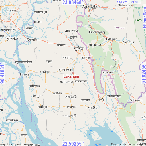
Lākshām GPS coordinates[2]
23° 14' 24.648" North, 91° 7' 17.148" East
| Map corner | latitude | longitude |
|---|---|---|
| Upper-left | 23.88468°, | 90.41831° |
| Center: | 23.24018°, | 91.12143° |
| Lower-right: | 22.59255°, | 91.82456° |
| Map W x H: | 143.7×143.7 km | = 89.3×89.3mi |
| max Lat: | 26.33338° ⇑64.1% North |
| Lākshām: | 23.24018° |
| min Lat: | ⇓35.9% South 20.85829° |
| min Long | Lākshām | max Long |
| 88.15638° | 91.12143° | 92.29773° |
| W 82.9%⇐ | ⇒17.1% E |
Elevation
Elevation of Lākshām is 10 m = 33 ft, and this is 7.9 m = 26 ft below average elevation for this country.
| Max E: |
79 m = 259 ft | 81.2% |
| Avg. | 17.9 m = 59 ft | |
| Lākshām | 10 m = 33 ft | |
Min E: |
2 m = 7 ft | 18.8% |
See also: Lākshām elevation on elevation.city.
Geographical zone
Lākshām is located in North Torrid zone (between Equator and Tropic of Cancer). Distance of this Northern Tropic circle is 21.9 km =13.6 mi to North.| Distance of | km | miles | from Lākshām |
|---|---|---|---|
| North Pole | 7423 | 4612.4 | to North |
| Arctic Circle | 4817.1 | 2993.2 | to North |
| Tropic Cancer | 21.9 | 13.6 | to North |
| Equator | 2584.1 | 1605.7 | to South |


Nearby cities:
15 places around Lākshām: (largest is in red/bold)
• Bhola
78.5 km =48.8 mi,  218°
218°
• Chhāgalnāiya
46.5 km =28.9 mi,  121°
121°
• Comilla
25.5 km =15.8 mi,  14°
14°
• Feni
37.7 km =23.4 mi,  131°
131°
• Hājīganj
27.2 km =16.9 mi,  272°
272°
• Lakshmīpur
44.4 km =27.6 mi, 222°
• Manikchari
86.1 km =53.5 mi, 121°
• Mehendiganj
76.4 km =47.5 mi,  232°
232°
• Nabīnagar
73.7 km =45.8 mi,  347°
347°
• Narsingdi
86.4 km =53.7 mi,  331°
331°
• Nārāyanganj
75.5 km =46.9 mi,  303°
303°
• Pālang
78.8 km =49 mi, 268°
• Rāipur
42.5 km =26.4 mi,  238°
238°
• Rāmganj
31.8 km =19.8 mi, 240°
• Sonārgaon
68.8 km =42.8 mi,  311°
311°
Sources, notices
• [Note1] Compared only with cities in Bangladesh existing in our database
• [Src1] Map data: © OpenStreetMap contributors (CC-BY-SA)
• [Src2] Other city data from geonames.org with taken over terms of usage.
• [Src3] Geographical zone / Annual Mean Temperature by Robert A. Rohde @ Wikipedia
