Hājīganj geodata
Hājīganj (Chittagong) is a populated place; located in Bangladesh in Asia/Dhaka (GMT+6) time zone. With population of 44,343 people, there are 71 cities with bigger population in this country. Compared to other cities in Bangladesh, 63.2% of cities are located further ↑North; 79.5% of cities are located further ←West and 65% of cities have higher elevation than Hājīganj. Note1
Administrative division(s):
- Level 1: Chittagong
- Level 2: Chandpur
- Level 3: Haziganj
- Level 4: Paurashava


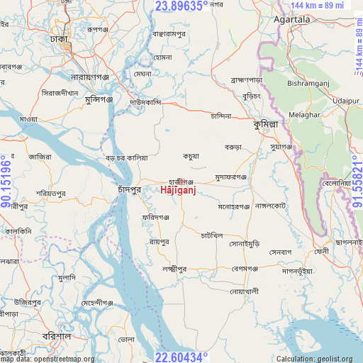
Hājīganj GPS coordinates[2]
23° 15' 6.876" North, 90° 51' 18.288" East
| Map corner | latitude | longitude |
|---|---|---|
| Upper-left | 23.89635°, | 90.15196° |
| Center: | 23.25191°, | 90.85508° |
| Lower-right: | 22.60434°, | 91.55821° |
| Map W x H: | 143.7×143.7 km | = 89.3×89.3mi |
| max Lat: | 26.33338° ⇑63.2% North |
| Hājīganj: | 23.25191° |
| min Lat: | ⇓36.8% South 20.85829° |
| min Long | Hājīganj | max Long |
| 88.15638° | 90.85508° | 92.29773° |
| W 79.5%⇐ | ⇒20.5% E |
Elevation
Elevation of Hājīganj is 13 m = 43 ft, and this is 4.9 m = 16 ft below average elevation for this country.
| Max E: |
79 m = 259 ft | 65% |
| Avg. | 17.9 m = 59 ft | |
| Hājīganj | 13 m = 43 ft | |
Min E: |
2 m = 7 ft | 35% |
See also: Hājīganj elevation on elevation.city.
Geographical zone
Hājīganj is located in North Torrid zone (between Equator and Tropic of Cancer). Distance of this Northern Tropic circle is 20.5 km =12.7 mi to North.| Distance of | km | miles | from Hājīganj |
|---|---|---|---|
| North Pole | 7421.7 | 4611.6 | to North |
| Arctic Circle | 4815.8 | 2992.4 | to North |
| Tropic Cancer | 20.5 | 12.7 | to North |
| Equator | 2585.4 | 1606.5 | to South |


Nearby cities:
15 places around Hājīganj: (largest is in red/bold)
• Bhola
66.4 km =41.3 mi,  199°
199°
• Char Bhadrāsan
64.5 km =40.1 mi,  275°
275°
• Comilla
41 km =25.5 mi,  55°
55°
• Dhaka
68.4 km =42.5 mi,  318°
318°
• Feni
61.3 km =38.1 mi,  115°
115°
• Lakshmīpur
34.3 km =21.3 mi,  184°
184°
• Lākshām
27.2 km =16.9 mi,  92°
92°
• Mehendiganj
58.3 km =36.2 mi,  214°
214°
• Mādārīpur
66.6 km =41.4 mi,  262°
262°
• Nārāyanganj
53.9 km =33.5 mi, 318°
• Paltan
70.1 km =43.6 mi, 320°
• Pālang
51.7 km =32.1 mi,  265°
265°
• Rāipur
25.3 km =15.7 mi, 200°
• Rāmganj
16.8 km =10.4 mi, 181°
• Sonārgaon
50.5 km =31.4 mi,  331°
331°
Sources, notices
• [Note1] Compared only with cities in Bangladesh existing in our database
• [Src1] Map data: © OpenStreetMap contributors (CC-BY-SA)
• [Src2] Other city data from geonames.org with taken over terms of usage.
• [Src3] Geographical zone / Annual Mean Temperature by Robert A. Rohde @ Wikipedia
