Feni geodata
Feni (Chittagong) is a populated place; located in Bangladesh in Asia/Dhaka (GMT+6) time zone. With population of 84,028 people, there are 42 cities with bigger population in this country. Compared to other cities in Bangladesh, 74.4% of cities are located further ↑North; 85.5% of cities are located further ←West and 70.1% of cities have higher elevation than Feni. Note1
Administrative division(s):
- Level 1: Chittagong
- Level 2: Feni
- Level 3: Feni Sadar Upazila
- Level 4: Paurashava


Feni GPS coordinates[2]
23° 0' 51.84" North, 91° 23' 47.76" East
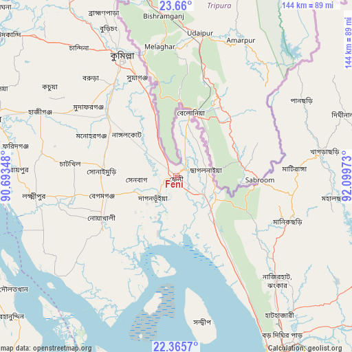
| Map corner | latitude | longitude |
|---|---|---|
| Upper-left | 23.66°, | 90.69348° |
| Center: | 23.0144°, | 91.3966° |
| Lower-right: | 22.3657°, | 92.09973° |
| Map W x H: | 143.9×143.9 km | = 89.4×89.4mi |
| max Lat: | 26.33338° ⇑74.4% North |
| Feni: | 23.0144° |
| min Lat: | ⇓25.6% South 20.85829° |
| min Long | Feni | max Long |
| 88.15638° | 91.3966° | 92.29773° |
| W 85.5%⇐ | ⇒14.5% E |
Elevation
Elevation of Feni is 12 m = 39 ft, and this is 5.9 m = 19 ft below average elevation for this country.
| Max E: |
79 m = 259 ft | 70.1% |
| Avg. | 17.9 m = 59 ft | |
| Feni | 12 m = 39 ft | |
Min E: |
2 m = 7 ft | 29.9% |
See also: Feni elevation on elevation.city.
Geographical zone
Feni is located in North Torrid zone (between Equator and Tropic of Cancer). Distance of this Northern Tropic circle is 47 km =29.2 mi to North.| Distance of | km | miles | from Feni |
|---|---|---|---|
| North Pole | 7448.1 | 4628 | to North |
| Arctic Circle | 4842.2 | 3008.8 | to North |
| Tropic Cancer | 47 | 29.2 | to North |
| Equator | 2559 | 1590.1 | to South |


Nearby cities:
15 places around Feni: (largest is in red/bold)
• Bhola
85.2 km =52.9 mi,  244°
244°
• Bibir Hat
54.6 km =33.9 mi,  132°
132°
• Burhānuddin
89.9 km =55.9 mi,  230°
230°
• Chhāgalnāiya
11.8 km =7.3 mi,  84°
84°
• Chittagong
87.4 km =54.3 mi,  149°
149°
• Comilla
54.2 km =33.7 mi,  336°
336°
• Hājīganj
61.3 km =38.1 mi,  295°
295°
• Khagrachhari
59.6 km =37 mi, 79°
• Lakshmīpur
58.5 km =36.4 mi,  262°
262°
• Lākshām
37.7 km =23.4 mi,  311°
311°
• Manikchari
49.5 km =30.8 mi,  113°
113°
• Raojān
75.6 km =47 mi, 134°
• Rāipur
64.4 km =40 mi,  272°
272°
• Rāmganj
56.7 km =35.2 mi,  279°
279°
• Sandwīp
55.9 km =34.7 mi,  173°
173°
Sources, notices
• [Note1] Compared only with cities in Bangladesh existing in our database
• [Src1] Map data: © OpenStreetMap contributors (CC-BY-SA)
• [Src2] Other city data from geonames.org with taken over terms of usage.
• [Src3] Geographical zone / Annual Mean Temperature by Robert A. Rohde @ Wikipedia
