Anzegem geodata
Anzegem (Flanders) is a populated place; located in Belgium in Europe/Brussels (GMT+2) time zone. With population of 13,920 people, there are 205 cities with bigger population in this country. Compared to other cities in Belgium, 53.1% of cities are located further ↓South; 86.6% of cities are located further →East and 50.5% of cities have lower elevation than Anzegem. Note1
Administrative division(s):
- Level 1: Flanders
- Level 2: Provincie West-Vlaanderen
- Level 3: Arrondissement Kortrijk
- Level 4: Anzegem


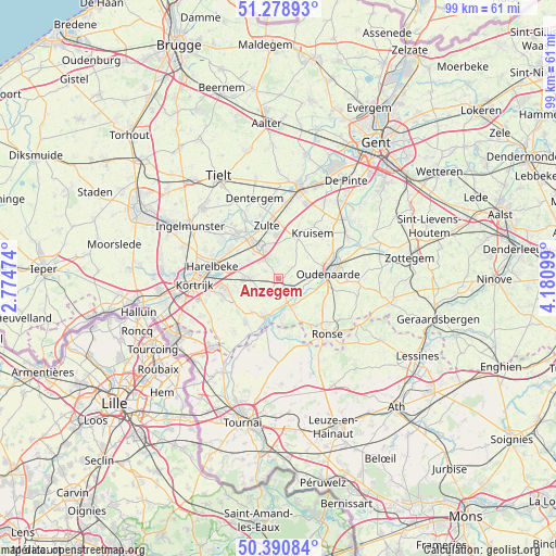
Anzegem GPS coordinates[2]
50° 50' 13.2" North, 3° 28' 40.296" East
| Map corner | latitude | longitude |
|---|---|---|
| Upper-left | 51.27893°, | 2.77474° |
| Center: | 50.837°, | 3.47786° |
| Lower-right: | 50.39084°, | 4.18099° |
| Map W x H: | 98.7×98.7 km | = 61.3×61.3mi |
| max Lat: | 51.46791° ⇑46.9% North |
| Anzegem: | 50.837° |
| min Lat: | ⇓53.1% South 49.53771° |
| min Long | Anzegem | max Long |
| 2.59368° | 3.47786° | 6.25749° |
| W 13.4%⇐ | ⇒86.6% E |
Elevation
Elevation of Anzegem is 51 m = 167 ft, and this is 48.5 m = 159 ft below average elevation for this country.
| Max E: |
582 m = 1909 ft | 49.5% |
| Avg. | 99.5 m = 326 ft | |
| Anzegem | 51 m = 167 ft | |
Min E: |
1 m = 3 ft | 50.5% |
See also: Belgium elevation on elevation.city.
Geographical zone
Anzegem is located in North temperate zone (between Tropic of Cancer and the Arctic Circle). Distance of this North polar circle is 1748.6 km =1086.5 mi to North.| Distance of | km | miles | from Anzegem |
|---|---|---|---|
| North Pole | 4354.5 | 2705.8 | to North |
| Arctic Circle | 1748.6 | 1086.5 | to North |
| Tropic Cancer | 3046.6 | 1893.1 | to South |
| Equator | 5652.5 | 3512.3 | to South |


Nearby cities:
15 places around Anzegem: (largest is in red/bold)
• Avelgem
7.1 km =4.4 mi,  198°
198°
• Celles
13.9 km =8.6 mi,  185°
185°
• Deerlijk
8.9 km =5.5 mi,  281°
281°
• Dentergem
14.8 km =9.2 mi,  343°
343°
• Harelbeke
12 km =7.5 mi, 278°
• Kruishoutem
7.9 km =4.9 mi,  25°
25°
• Kuurne
13.8 km =8.6 mi, 276°
• Oostrozebeke
13.5 km =8.4 mi,  313°
313°
• Oudenaarde
9.3 km =5.8 mi,  79°
79°
• Ronse
13.3 km =8.3 mi,  139°
139°
• Waregem
6.8 km =4.2 mi,  328°
328°
• Wielsbeke
10.5 km =6.5 mi, 311°
• Zingem
14.4 km =8.9 mi,  58°
58°
• Zulte
9.4 km =5.8 mi,  347°
347°
• Zwevegem
10.2 km =6.3 mi,  254°
254°
Sources, notices
• [Note1] Compared only with cities in Belgium existing in our database
• [Src1] Map data: © OpenStreetMap contributors (CC-BY-SA)
• [Src2] Other city data from geonames.org with taken over terms of usage.
• [Src3] Geographical zone / Annual Mean Temperature by Robert A. Rohde @ Wikipedia
