Zonhoven geodata
Zonhoven (Flanders) is a populated place; located in Belgium in Europe/Brussels (GMT+2) time zone. With population of 19,922 people, there are 125 cities with bigger population in this country. Compared to other cities in Belgium, 69.5% of cities are located further ↓South; 79.8% of cities are located further ←West and 53.4% of cities have higher elevation than Zonhoven. Note1
Administrative division(s):
- Level 1: Flanders
- Level 2: Provincie Limburg
- Level 3: Arrondissement Hasselt
- Level 4: Zonhoven


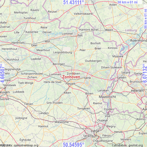
Zonhoven GPS coordinates[2]
50° 59' 26.304" North, 5° 22' 5.484" East
| Map corner | latitude | longitude |
|---|---|---|
| Upper-left | 51.43111°, | 4.66507° |
| Center: | 50.99064°, | 5.36819° |
| Lower-right: | 50.54595°, | 6.07132° |
| Map W x H: | 98.4×98.4 km | = 61.1×61.1mi |
| max Lat: | 51.46791° ⇑30.5% North |
| Zonhoven: | 50.99064° |
| min Lat: | ⇓69.5% South 49.53771° |
| min Long | Zonhoven | max Long |
| 2.59368° | 5.36819° | 6.25749° |
| W 79.8%⇐ | ⇒20.2% E |
Elevation
Elevation of Zonhoven is 44 m = 144 ft, and this is 55.5 m = 182 ft below average elevation for this country.
| Max E: |
582 m = 1909 ft | 53.4% |
| Avg. | 99.5 m = 326 ft | |
| Zonhoven | 44 m = 144 ft | |
Min E: |
1 m = 3 ft | 46.6% |
See also: Belgium elevation on elevation.city.
Geographical zone
Zonhoven is located in North temperate zone (between Tropic of Cancer and the Arctic Circle). Distance of this North polar circle is 1731.5 km =1075.9 mi to North.| Distance of | km | miles | from Zonhoven |
|---|---|---|---|
| North Pole | 4337.4 | 2695.1 | to North |
| Arctic Circle | 1731.5 | 1075.9 | to North |
| Tropic Cancer | 3063.7 | 1903.7 | to South |
| Equator | 5669.6 | 3522.9 | to South |


Nearby cities:
15 places around Zonhoven: (largest is in red/bold)
• Alken
13.5 km =8.4 mi,  198°
198°
• As
15.3 km =9.5 mi,  82°
82°
• Beringen
11.9 km =7.4 mi,  303°
303°
• Diepenbeek
9.9 km =6.2 mi,  158°
158°
• Genk
9.7 km =6 mi,  107°
107°
• Hasselt
7 km =4.3 mi, 197°
• Helchteren
7.3 km =4.5 mi,  7°
7°
• Herk-de-Stad
15.2 km =9.4 mi,  248°
248°
• Heusden
8 km =5 mi,  309°
309°
• Houthalen
4.9 km =3 mi, 5°
• Kortessem
14.7 km =9.1 mi,  174°
174°
• Lummen
12.4 km =7.7 mi,  268°
268°
• Sint-Joris
14.9 km =9.3 mi,  206°
206°
• Terkoest
12.1 km =7.5 mi, 212°
• Zutendaal
15.9 km =9.9 mi, 113°
Sources, notices
• [Note1] Compared only with cities in Belgium existing in our database
• [Src1] Map data: © OpenStreetMap contributors (CC-BY-SA)
• [Src2] Other city data from geonames.org with taken over terms of usage.
• [Src3] Geographical zone / Annual Mean Temperature by Robert A. Rohde @ Wikipedia
