Diepenbeek geodata
Diepenbeek (Flanders) is a populated place; located in Belgium in Europe/Brussels (GMT+2) time zone. With population of 17,699 people, there are 146 cities with bigger population in this country. Compared to other cities in Belgium, 61% of cities are located further ↓South; 81.6% of cities are located further ←West and 50.2% of cities have lower elevation than Diepenbeek. Note1
Administrative division(s):
- Level 1: Flanders
- Level 2: Provincie Limburg
- Level 3: Arrondissement Hasselt
- Level 4: Diepenbeek


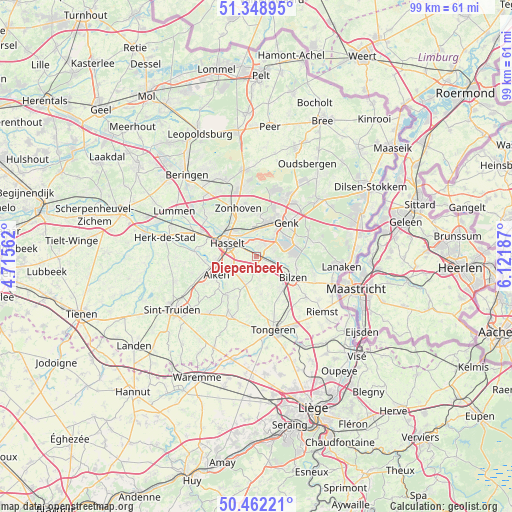
Diepenbeek GPS coordinates[2]
50° 54' 27.684" North, 5° 25' 7.5" East
| Map corner | latitude | longitude |
|---|---|---|
| Upper-left | 51.34895°, | 4.71562° |
| Center: | 50.90769°, | 5.41875° |
| Lower-right: | 50.46221°, | 6.12187° |
| Map W x H: | 98.6×98.6 km | = 61.3×61.3mi |
| max Lat: | 51.46791° ⇑39% North |
| Diepenbeek: | 50.90769° |
| min Lat: | ⇓61% South 49.53771° |
| min Long | Diepenbeek | max Long |
| 2.59368° | 5.41875° | 6.25749° |
| W 81.6%⇐ | ⇒18.4% E |
Elevation
Elevation of Diepenbeek is 50 m = 164 ft, and this is 49.5 m = 162 ft below average elevation for this country.
| Max E: |
582 m = 1909 ft | 49.8% |
| Avg. | 99.5 m = 326 ft | |
| Diepenbeek | 50 m = 164 ft | |
Min E: |
1 m = 3 ft | 50.2% |
See also: Belgium elevation on elevation.city.
Geographical zone
Diepenbeek is located in North temperate zone (between Tropic of Cancer and the Arctic Circle). Distance of this North polar circle is 1740.8 km =1081.7 mi to North.| Distance of | km | miles | from Diepenbeek |
|---|---|---|---|
| North Pole | 4346.7 | 2700.9 | to North |
| Arctic Circle | 1740.8 | 1081.7 | to North |
| Tropic Cancer | 3054.5 | 1898 | to South |
| Equator | 5660.4 | 3517.2 | to South |


Nearby cities:
15 places around Diepenbeek: (largest is in red/bold)
• Alken
8.7 km =5.4 mi,  245°
245°
• As
16.1 km =10 mi,  46°
46°
• Bilzen
8 km =5 mi,  118°
118°
• Borgloon
12.6 km =7.8 mi,  204°
204°
• Genk
8.6 km =5.3 mi,  42°
42°
• Hasselt
6.2 km =3.9 mi,  294°
294°
• Hoeselt
8.3 km =5.2 mi,  144°
144°
• Houthalen
14.4 km =8.9 mi,  347°
347°
• Kortessem
5.8 km =3.6 mi, 200°
• Sint-Joris
11.1 km =6.9 mi, 248°
• Terkoest
10 km =6.2 mi,  264°
264°
• Tongeren
14.5 km =9 mi,  167°
167°
• Wellen
9.3 km =5.8 mi,  217°
217°
• Zonhoven
9.9 km =6.2 mi,  338°
338°
• Zutendaal
11.3 km =7 mi,  75°
75°
Sources, notices
• [Note1] Compared only with cities in Belgium existing in our database
• [Src1] Map data: © OpenStreetMap contributors (CC-BY-SA)
• [Src2] Other city data from geonames.org with taken over terms of usage.
• [Src3] Geographical zone / Annual Mean Temperature by Robert A. Rohde @ Wikipedia
