Terkoest geodata
Terkoest (Flanders) is a populated place; located in Belgium in Europe/Brussels (GMT+1) time zone. With population of 2,350 people, there are 527 cities with bigger population in this country. Compared to other cities in Belgium, 60.1% of cities are located further ↓South; 76.2% of cities are located further ←West and 57.9% of cities have higher elevation than Terkoest. Note1
Administrative division(s):
- Level 1: Flanders
- Level 2: Provincie Limburg
- Level 3: Arrondissement Tongeren
- Level 4: Alken


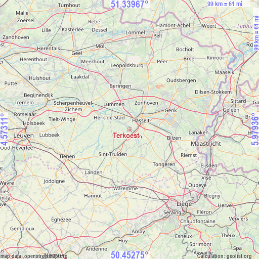
Terkoest GPS coordinates[2]
50° 53' 53.952" North, 5° 16' 34.428" East
| Map corner | latitude | longitude |
|---|---|---|
| Upper-left | 51.33967°, | 4.57311° |
| Center: | 50.89832°, | 5.27623° |
| Lower-right: | 50.45275°, | 5.97936° |
| Map W x H: | 98.6×98.6 km | = 61.3×61.3mi |
| max Lat: | 51.46791° ⇑39.9% North |
| Terkoest: | 50.89832° |
| min Lat: | ⇓60.1% South 49.53771° |
| min Long | Terkoest | max Long |
| 2.59368° | 5.27623° | 6.25749° |
| W 76.2%⇐ | ⇒23.8% E |
Elevation
Elevation of Terkoest is 37 m = 121 ft, and this is 62.5 m = 205 ft below average elevation for this country.
| Max E: |
582 m = 1909 ft | 57.9% |
| Avg. | 99.5 m = 326 ft | |
| Terkoest | 37 m = 121 ft | |
Min E: |
1 m = 3 ft | 42.1% |
See also: Belgium elevation on elevation.city.
Geographical zone
Terkoest is located in North temperate zone (between Tropic of Cancer and the Arctic Circle). Distance of this North polar circle is 1741.8 km =1082.3 mi to North.| Distance of | km | miles | from Terkoest |
|---|---|---|---|
| North Pole | 4347.7 | 2701.5 | to North |
| Arctic Circle | 1741.8 | 1082.3 | to North |
| Tropic Cancer | 3053.4 | 1897.3 | to South |
| Equator | 5659.4 | 3516.6 | to South |


Nearby cities:
15 places around Terkoest: (largest is in red/bold)
• Alken
3.3 km =2.1 mi,  140°
140°
• Borgloon
11.4 km =7.1 mi,  155°
155°
• Diepenbeek
10 km =6.2 mi,  84°
84°
• Geetbets
11.5 km =7.1 mi,  267°
267°
• Halen
12.9 km =8 mi,  295°
295°
• Hasselt
5.6 km =3.5 mi,  49°
49°
• Herk-de-Stad
9 km =5.6 mi, 301°
• Kortessem
9.1 km =5.7 mi,  118°
118°
• Lummen
11.6 km =7.2 mi,  329°
329°
• Nieuwerkerken
6.9 km =4.3 mi,  236°
236°
• Sint-Joris
3 km =1.9 mi,  185°
185°
• Sint-Truiden
11 km =6.8 mi,  214°
214°
• Wellen
7.7 km =4.8 mi,  145°
145°
• Zonhoven
12.1 km =7.5 mi,  32°
32°
• Zoutleeuw
14.1 km =8.8 mi, 239°
Sources, notices
• [Note1] Compared only with cities in Belgium existing in our database
• [Src1] Map data: © OpenStreetMap contributors (CC-BY-SA)
• [Src2] Other city data from geonames.org with taken over terms of usage.
• [Src3] Geographical zone / Annual Mean Temperature by Robert A. Rohde @ Wikipedia
