Genk geodata
Genk (Flanders) is a populated place; located in Belgium in Europe/Brussels (GMT+2) time zone. With population of 63,666 people, there are 18 cities with bigger population in this country. Compared to other cities in Belgium, 66.8% of cities are located further ↓South; 84.3% of cities are located further ←West and 57% of cities have lower elevation than Genk. Note1
Administrative division(s):
- Level 1: Flanders
- Level 2: Provincie Limburg
- Level 3: Arrondissement Hasselt
- Level 4: Genk


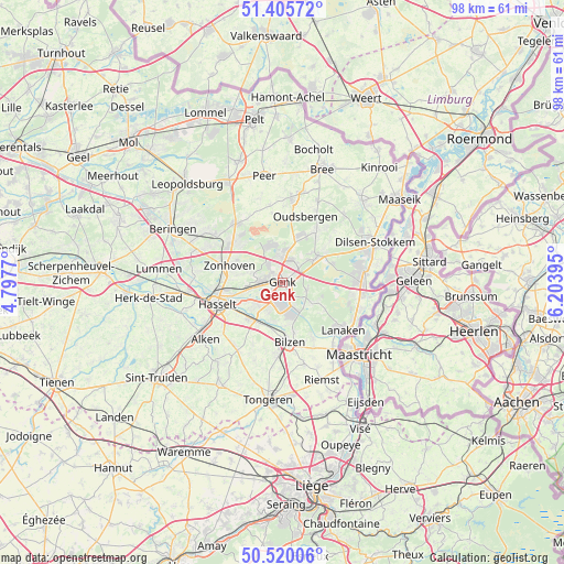
Genk GPS coordinates[2]
50° 57' 54" North, 5° 30' 2.952" East
| Map corner | latitude | longitude |
|---|---|---|
| Upper-left | 51.40572°, | 4.7977° |
| Center: | 50.965°, | 5.50082° |
| Lower-right: | 50.52006°, | 6.20395° |
| Map W x H: | 98.5×98.5 km | = 61.2×61.2mi |
| max Lat: | 51.46791° ⇑33.2% North |
| Genk: | 50.965° |
| min Lat: | ⇓66.8% South 49.53771° |
| min Long | Genk | max Long |
| 2.59368° | 5.50082° | 6.25749° |
| W 84.3%⇐ | ⇒15.7% E |
Elevation
Elevation of Genk is 66 m = 217 ft, and this is 33.5 m = 110 ft below average elevation for this country.
| Max E: |
582 m = 1909 ft | 43% |
| Avg. | 99.5 m = 326 ft | |
| Genk | 66 m = 217 ft | |
Min E: |
1 m = 3 ft | 57% |
See also: Genk elevation on elevation.city.
Geographical zone
Genk is located in North temperate zone (between Tropic of Cancer and the Arctic Circle). Distance of this North polar circle is 1734.4 km =1077.7 mi to North.| Distance of | km | miles | from Genk |
|---|---|---|---|
| North Pole | 4340.3 | 2696.9 | to North |
| Arctic Circle | 1734.4 | 1077.7 | to North |
| Tropic Cancer | 3060.9 | 1902 | to South |
| Equator | 5666.8 | 3521.2 | to South |


Nearby cities:
15 places around Genk: (largest is in red/bold)
• Alken
16.9 km =10.5 mi,  233°
233°
• As
7.5 km =4.7 mi,  51°
51°
• Bilzen
10.3 km =6.4 mi,  173°
173°
• Diepenbeek
8.6 km =5.3 mi,  222°
222°
• Hasselt
12 km =7.5 mi,  251°
251°
• Helchteren
13.1 km =8.1 mi,  320°
320°
• Hoeselt
13.1 km =8.1 mi,  184°
184°
• Houthalen
11.7 km =7.3 mi,  311°
311°
• Kortessem
14.1 km =8.8 mi,  213°
213°
• Lanaken
13 km =8.1 mi,  127°
127°
• Maasmechelen
13.6 km =8.5 mi,  89°
89°
• Opglabbeek
10.4 km =6.5 mi,  33°
33°
• Terkoest
17.4 km =10.8 mi,  244°
244°
• Zonhoven
9.7 km =6 mi,  287°
287°
• Zutendaal
6.3 km =3.9 mi,  124°
124°
Sources, notices
• [Note1] Compared only with cities in Belgium existing in our database
• [Src1] Map data: © OpenStreetMap contributors (CC-BY-SA)
• [Src2] Other city data from geonames.org with taken over terms of usage.
• [Src3] Geographical zone / Annual Mean Temperature by Robert A. Rohde @ Wikipedia
