Yvoir geodata
Yvoir (Wallonia) is a populated place; located in Belgium in Europe/Brussels (GMT+2) time zone. With population of 8,169 people, there are 357 cities with bigger population in this country. Compared to other cities in Belgium, 87.9% of cities are located further ↑North; 61.6% of cities are located further ←West and 64.4% of cities have lower elevation than Yvoir. Note1
Administrative division(s):
- Level 1: Wallonia
- Level 2: Province de Namur
- Level 3: Arrondissement de Dinant
- Level 4: Yvoir


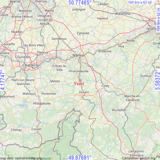
Yvoir GPS coordinates[2]
50° 19' 40.44" North, 4° 52' 50.124" East
| Map corner | latitude | longitude |
|---|---|---|
| Upper-left | 50.77465°, | 4.17747° |
| Center: | 50.3279°, | 4.88059° |
| Lower-right: | 49.87691°, | 5.58372° |
| Map W x H: | 99.8×99.8 km | = 62×62mi |
| max Lat: | 51.46791° ⇑87.9% North |
| Yvoir: | 50.3279° |
| min Lat: | ⇓12.1% South 49.53771° |
| min Long | Yvoir | max Long |
| 2.59368° | 4.88059° | 6.25749° |
| W 61.6%⇐ | ⇒38.4% E |
Elevation
Elevation of Yvoir is 96 m = 315 ft, and this is 3.5 m = 11 ft below average elevation for this country.
| Max E: |
582 m = 1909 ft | 35.6% |
| Avg. | 99.5 m = 326 ft | |
| Yvoir | 96 m = 315 ft | |
Min E: |
1 m = 3 ft | 64.4% |
See also: Belgium elevation on elevation.city.
Geographical zone
Yvoir is located in North temperate zone (between Tropic of Cancer and the Arctic Circle). Distance of this North polar circle is 1805.2 km =1121.7 mi to North.| Distance of | km | miles | from Yvoir |
|---|---|---|---|
| North Pole | 4411.1 | 2740.9 | to North |
| Arctic Circle | 1805.2 | 1121.7 | to North |
| Tropic Cancer | 2990 | 1857.9 | to South |
| Equator | 5595.9 | 3477.1 | to South |


Nearby cities:
15 places around Yvoir: (largest is in red/bold)
• Anhée
2 km =1.2 mi,  184°
184°
• Assesse
11 km =6.8 mi,  65°
65°
• Ciney
16 km =9.9 mi,  103°
103°
• Dinant
8.1 km =5 mi,  164°
164°
• Floreffe
14.6 km =9.1 mi,  324°
324°
• Fosses-la-Ville
15.1 km =9.4 mi,  299°
299°
• Gesves
16 km =9.9 mi,  59°
59°
• Hamois
19.6 km =12.2 mi,  86°
86°
• Hastière-Lavaux
12.8 km =8 mi,  198°
198°
• Houyet
18.2 km =11.3 mi,  150°
150°
• La Bruyère
20.3 km =12.6 mi,  291°
291°
• Mettet
15.5 km =9.6 mi,  267°
267°
• Namur
15.5 km =9.6 mi,  356°
356°
• Onhaye
10 km =6.2 mi, 196°
• Profondeville
5.4 km =3.4 mi,  348°
348°
Sources, notices
• [Note1] Compared only with cities in Belgium existing in our database
• [Src1] Map data: © OpenStreetMap contributors (CC-BY-SA)
• [Src2] Other city data from geonames.org with taken over terms of usage.
• [Src3] Geographical zone / Annual Mean Temperature by Robert A. Rohde @ Wikipedia
