Fosses-la-Ville geodata
Fosses-la-Ville (Wallonia) is a populated place; located in Belgium in Europe/Brussels (GMT+2) time zone. With population of 9,062 people, there are 334 cities with bigger population in this country. Compared to other cities in Belgium, 85.2% of cities are located further ↑North; 54.5% of cities are located further ←West and 80% of cities have lower elevation than Fosses-la-Ville. Note1
Administrative division(s):
- Level 1: Wallonia
- Level 2: Province de Namur
- Level 3: Arrondissement de Namur
- Level 4: Fosses-la-Ville


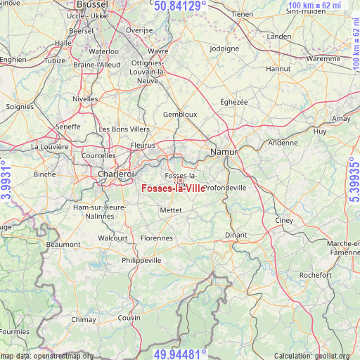
Fosses-la-Ville GPS coordinates[2]
50° 23' 42.612" North, 4° 41' 46.428" East
| Map corner | latitude | longitude |
|---|---|---|
| Upper-left | 50.84129°, | 3.9931° |
| Center: | 50.39517°, | 4.69623° |
| Lower-right: | 49.94481°, | 5.39935° |
| Map W x H: | 99.7×99.7 km | = 62×62mi |
| max Lat: | 51.46791° ⇑85.2% North |
| Fosses-la-Ville: | 50.39517° |
| min Lat: | ⇓14.8% South 49.53771° |
| min Long | Fosses-la-Ville | max Long |
| 2.59368° | 4.69623° | 6.25749° |
| W 54.5%⇐ | ⇒45.5% E |
Elevation
Elevation of Fosses-la-Ville is 176 m = 577 ft, and this is 76.5 m = 251 ft above average elevation for this country.
| Max E: |
582 m = 1909 ft | 20% |
| Fosses-la-Ville | 176 m 577 ft | |
| Avg. | 99.5 m = 326 ft | |
Min E: |
1 m = 3 ft | 80% |
See also: Belgium elevation on elevation.city.
Geographical zone
Fosses-la-Ville is located in North temperate zone (between Tropic of Cancer and the Arctic Circle). Distance of this North polar circle is 1797.8 km =1117.1 mi to North.| Distance of | km | miles | from Fosses-la-Ville |
|---|---|---|---|
| North Pole | 4403.6 | 2736.3 | to North |
| Arctic Circle | 1797.8 | 1117.1 | to North |
| Tropic Cancer | 2997.5 | 1862.6 | to South |
| Equator | 5603.4 | 3481.8 | to South |


Nearby cities:
15 places around Fosses-la-Ville: (largest is in red/bold)
• Aiseau
8 km =5 mi,  283°
283°
• Anhée
16 km =9.9 mi,  126°
126°
• Charleroi
17.9 km =11.1 mi, 275°
• Châtelet
11.9 km =7.4 mi,  274°
274°
• Farciennes
11.6 km =7.2 mi,  289°
289°
• Fleurus
14.3 km =8.9 mi,  313°
313°
• Floreffe
6.3 km =3.9 mi,  45°
45°
• Florennes
17.2 km =10.7 mi,  201°
201°
• Gerpinnes
13.6 km =8.5 mi,  242°
242°
• La Bruyère
5.8 km =3.6 mi, 269°
• Mettet
8.6 km =5.3 mi, 196°
• Namur
14.5 km =9 mi,  56°
56°
• Profondeville
12.2 km =7.6 mi,  100°
100°
• Sombreffe
16.3 km =10.1 mi,  335°
335°
• Yvoir
15.1 km =9.4 mi,  119°
119°
Sources, notices
• [Note1] Compared only with cities in Belgium existing in our database
• [Src1] Map data: © OpenStreetMap contributors (CC-BY-SA)
• [Src2] Other city data from geonames.org with taken over terms of usage.
• [Src3] Geographical zone / Annual Mean Temperature by Robert A. Rohde @ Wikipedia
