Assesse geodata
Assesse (Wallonia) is a populated place; located in Belgium in Europe/Brussels (GMT+2) time zone. With population of 6,279 people, there are 417 cities with bigger population in this country. Compared to other cities in Belgium, 86.3% of cities are located further ↑North; 67.1% of cities are located further ←West and 87.7% of cities have lower elevation than Assesse. Note1
Administrative division(s):
- Level 1: Wallonia
- Level 2: Province de Namur
- Level 3: Arrondissement de Namur
- Level 4: Assesse


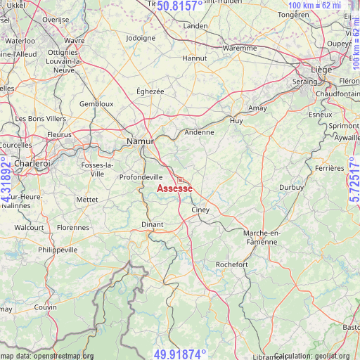
Assesse GPS coordinates[2]
50° 22' 9.624" North, 5° 1' 19.344" East
| Map corner | latitude | longitude |
|---|---|---|
| Upper-left | 50.8157°, | 4.31892° |
| Center: | 50.36934°, | 5.02204° |
| Lower-right: | 49.91874°, | 5.72517° |
| Map W x H: | 99.7×99.7 km | = 62×62mi |
| max Lat: | 51.46791° ⇑86.3% North |
| Assesse: | 50.36934° |
| min Lat: | ⇓13.7% South 49.53771° |
| min Long | Assesse | max Long |
| 2.59368° | 5.02204° | 6.25749° |
| W 67.1%⇐ | ⇒32.9% E |
Elevation
Elevation of Assesse is 247 m = 810 ft, and this is 147.5 m = 484 ft above average elevation for this country.
| Max E: |
582 m = 1909 ft | 12.3% |
| Assesse | 247 m 810 ft | |
| Avg. | 99.5 m = 326 ft | |
Min E: |
1 m = 3 ft | 87.7% |
See also: Belgium elevation on elevation.city.
Geographical zone
Assesse is located in North temperate zone (between Tropic of Cancer and the Arctic Circle). Distance of this North polar circle is 1800.6 km =1118.8 mi to North.| Distance of | km | miles | from Assesse |
|---|---|---|---|
| North Pole | 4406.5 | 2738.1 | to North |
| Arctic Circle | 1800.6 | 1118.8 | to North |
| Tropic Cancer | 2994.6 | 1860.8 | to South |
| Equator | 5600.5 | 3480 | to South |


Nearby cities:
15 places around Assesse: (largest is in red/bold)
• Andenne
14.3 km =8.9 mi,  21°
21°
• Anhée
12.1 km =7.5 mi,  237°
237°
• Ciney
10 km =6.2 mi,  146°
146°
• Dinant
14.6 km =9.1 mi,  212°
212°
• Gesves
5.2 km =3.2 mi,  46°
46°
• Hamois
10.1 km =6.3 mi,  108°
108°
• Havelange
15.5 km =9.6 mi,  81°
81°
• Hingeon
17.4 km =10.8 mi,  356°
356°
• Marchin
19 km =11.8 mi,  55°
55°
• Marchovelette
18 km =11.2 mi,  341°
341°
• Namur
15.4 km =9.6 mi,  314°
314°
• Ohey
10.3 km =6.4 mi,  44°
44°
• Onhaye
19.2 km =11.9 mi,  222°
222°
• Profondeville
11.2 km =7 mi,  273°
273°
• Yvoir
11 km =6.8 mi,  245°
245°
Sources, notices
• [Note1] Compared only with cities in Belgium existing in our database
• [Src1] Map data: © OpenStreetMap contributors (CC-BY-SA)
• [Src2] Other city data from geonames.org with taken over terms of usage.
• [Src3] Geographical zone / Annual Mean Temperature by Robert A. Rohde @ Wikipedia
