Namur geodata
Namur (Wallonia) is a seat of a first-order administrative division; located in Belgium in Europe/Brussels (GMT+2) time zone. With population of 106,284 people, there are 6 cities with bigger population in this country. Compared to other cities in Belgium, 79.2% of cities are located further ↑North; 61% of cities are located further ←West and 62.8% of cities have lower elevation than Namur. Note1
Administrative division(s):
- Level 1: Wallonia
- Level 2: Province de Namur
- Level 3: Arrondissement de Namur
- Level 4: Namur


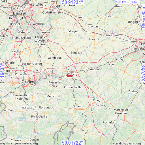
Namur GPS coordinates[2]
50° 28' 0.84" North, 4° 52' 2.856" East
| Map corner | latitude | longitude |
|---|---|---|
| Upper-left | 50.91234°, | 4.16433° |
| Center: | 50.4669°, | 4.86746° |
| Lower-right: | 50.01722°, | 5.57058° |
| Map W x H: | 99.5×99.5 km | = 61.8×61.8mi |
| max Lat: | 51.46791° ⇑79.2% North |
| Namur: | 50.4669° |
| min Lat: | ⇓20.8% South 49.53771° |
| min Long | Namur | max Long |
| 2.59368° | 4.86746° | 6.25749° |
| W 61%⇐ | ⇒39% E |
Elevation
Elevation of Namur is 88 m = 289 ft, and this is 11.5 m = 38 ft below average elevation for this country.
| Max E: |
582 m = 1909 ft | 37.2% |
| Avg. | 99.5 m = 326 ft | |
| Namur | 88 m = 289 ft | |
Min E: |
1 m = 3 ft | 62.8% |
See also: Namur elevation on elevation.city.
Geographical zone
Namur is located in North temperate zone (between Tropic of Cancer and the Arctic Circle). Distance of this North polar circle is 1789.8 km =1112.1 mi to North.| Distance of | km | miles | from Namur |
|---|---|---|---|
| North Pole | 4395.7 | 2731.4 | to North |
| Arctic Circle | 1789.8 | 1112.1 | to North |
| Tropic Cancer | 3005.5 | 1867.5 | to South |
| Equator | 5611.4 | 3486.8 | to South |


Nearby cities:
15 places around Namur: (largest is in red/bold)
• Andenne
16.3 km =10.1 mi,  81°
81°
• Assesse
15.4 km =9.6 mi,  134°
134°
• Cortil-Wodon
12.9 km =8 mi,  29°
29°
• Floreffe
8.4 km =5.2 mi,  244°
244°
• Forville
15.1 km =9.4 mi,  37°
37°
• Fosses-la-Ville
14.5 km =9 mi, 236°
• Gembloux
15.9 km =9.9 mi,  311°
311°
• Gesves
16.4 km =10.2 mi,  116°
116°
• Hingeon
11.9 km =7.4 mi,  56°
56°
• Marchovelette
8.1 km =5 mi, 39°
• Noville-les-Bois
13 km =8.1 mi, 39°
• Pontillas
14.2 km =8.8 mi,  49°
49°
• Profondeville
10.1 km =6.3 mi,  180°
180°
• Yvoir
15.5 km =9.6 mi, 176°
• Éghezée
14.1 km =8.8 mi,  12°
12°
Sources, notices
• [Note1] Compared only with cities in Belgium existing in our database
• [Src1] Map data: © OpenStreetMap contributors (CC-BY-SA)
• [Src2] Other city data from geonames.org with taken over terms of usage.
• [Src3] Geographical zone / Annual Mean Temperature by Robert A. Rohde @ Wikipedia
