Merksplas geodata
Merksplas (Flanders) is a populated place; located in Belgium in Europe/Brussels (GMT+2) time zone. With population of 7,963 people, there are 368 cities with bigger population in this country. Compared to other cities in Belgium, 98.9% of cities are located further ↓South; 60.8% of cities are located further ←West and 64.6% of cities have higher elevation than Merksplas. Note1
Administrative division(s):
- Level 1: Flanders
- Level 2: Provincie Antwerpen
- Level 3: Arrondissement Turnhout
- Level 4: Merksplas


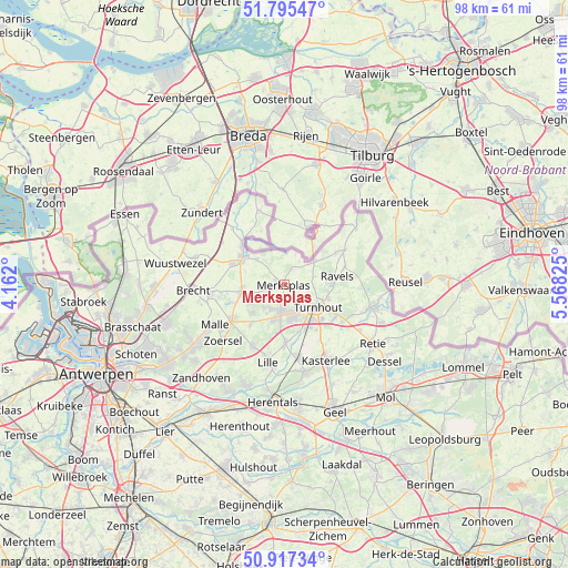
Merksplas GPS coordinates[2]
51° 21' 30.636" North, 4° 51' 54.468" East
| Map corner | latitude | longitude |
|---|---|---|
| Upper-left | 51.79547°, | 4.162° |
| Center: | 51.35851°, | 4.86513° |
| Lower-right: | 50.91734°, | 5.56825° |
| Map W x H: | 97.6×97.6 km | = 60.6×60.6mi |
| max Lat: | 51.46791° ⇑1.1% North |
| Merksplas: | 51.35851° |
| min Lat: | ⇓98.9% South 49.53771° |
| min Long | Merksplas | max Long |
| 2.59368° | 4.86513° | 6.25749° |
| W 60.8%⇐ | ⇒39.2% E |
Elevation
Elevation of Merksplas is 26 m = 85 ft, and this is 73.5 m = 241 ft below average elevation for this country.
| Max E: |
582 m = 1909 ft | 64.6% |
| Avg. | 99.5 m = 326 ft | |
| Merksplas | 26 m = 85 ft | |
Min E: |
1 m = 3 ft | 35.4% |
See also: Belgium elevation on elevation.city.
Geographical zone
Merksplas is located in North temperate zone (between Tropic of Cancer and the Arctic Circle). Distance of this North polar circle is 1690.6 km =1050.5 mi to North.| Distance of | km | miles | from Merksplas |
|---|---|---|---|
| North Pole | 4296.5 | 2669.7 | to North |
| Arctic Circle | 1690.6 | 1050.5 | to North |
| Tropic Cancer | 3104.6 | 1929.1 | to South |
| Equator | 5710.5 | 3548.3 | to South |


Nearby cities:
15 places around Merksplas: (largest is in red/bold)
• Arendonk
15.6 km =9.7 mi,  104°
104°
• Baarle-Hertog
5.5 km =3.4 mi,  19°
19°
• Beerse
4.4 km =2.7 mi,  190°
190°
• Brecht
15.8 km =9.8 mi,  266°
266°
• Hoogstraten
8.6 km =5.3 mi,  302°
302°
• Kasterlee
14.8 km =9.2 mi,  151°
151°
• Lille
13.3 km =8.3 mi, 192°
• Oostmalle
11.2 km =7 mi,  234°
234°
• Oud-Turnhout
9.3 km =5.8 mi,  117°
117°
• Ravels
9 km =5.6 mi,  79°
79°
• Retie
18.2 km =11.3 mi, 124°
• Rijkevorsel
7.4 km =4.6 mi,  260°
260°
• Turnhout
6.8 km =4.2 mi,  125°
125°
• Vosselaar
5.8 km =3.6 mi,  162°
162°
• Zoersel
14.6 km =9.1 mi, 226°
Sources, notices
• [Note1] Compared only with cities in Belgium existing in our database
• [Src1] Map data: © OpenStreetMap contributors (CC-BY-SA)
• [Src2] Other city data from geonames.org with taken over terms of usage.
• [Src3] Geographical zone / Annual Mean Temperature by Robert A. Rohde @ Wikipedia
