Hoogstraten geodata
Hoogstraten (Flanders) is a populated place; located in Belgium in Europe/Brussels (GMT+2) time zone. With population of 18,524 people, there are 134 cities with bigger population in this country. Compared to other cities in Belgium, 99.6% of cities are located further ↓South; 57.6% of cities are located further ←West and 71.3% of cities have higher elevation than Hoogstraten. Note1
Administrative division(s):
- Level 1: Flanders
- Level 2: Provincie Antwerpen
- Level 3: Arrondissement Turnhout
- Level 4: Hoogstraten


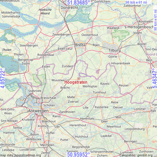
Hoogstraten GPS coordinates[2]
51° 24' 1.044" North, 4° 45' 37.224" East
| Map corner | latitude | longitude |
|---|---|---|
| Upper-left | 51.83685°, | 4.05722° |
| Center: | 51.40029°, | 4.76034° |
| Lower-right: | 50.95952°, | 5.46347° |
| Map W x H: | 97.5×97.5 km | = 60.6×60.6mi |
| max Lat: | 51.46791° ⇑0.4% North |
| Hoogstraten: | 51.40029° |
| min Lat: | ⇓99.6% South 49.53771° |
| min Long | Hoogstraten | max Long |
| 2.59368° | 4.76034° | 6.25749° |
| W 57.6%⇐ | ⇒42.4% E |
Elevation
Elevation of Hoogstraten is 21 m = 69 ft, and this is 78.5 m = 258 ft below average elevation for this country.
| Max E: |
582 m = 1909 ft | 71.3% |
| Avg. | 99.5 m = 326 ft | |
| Hoogstraten | 21 m = 69 ft | |
Min E: |
1 m = 3 ft | 28.7% |
See also: Belgium elevation on elevation.city.
Geographical zone
Hoogstraten is located in North temperate zone (between Tropic of Cancer and the Arctic Circle). Distance of this North polar circle is 1686 km =1047.6 mi to North.| Distance of | km | miles | from Hoogstraten |
|---|---|---|---|
| North Pole | 4291.9 | 2666.9 | to North |
| Arctic Circle | 1686 | 1047.6 | to North |
| Tropic Cancer | 3109.3 | 1932 | to South |
| Equator | 5715.2 | 3551.3 | to South |


Nearby cities:
15 places around Hoogstraten: (largest is in red/bold)
• Baarle-Hertog
9.2 km =5.7 mi,  86°
86°
• Beerse
11.1 km =6.9 mi,  144°
144°
• Brecht
10.1 km =6.3 mi,  236°
236°
• Essen
21.5 km =13.4 mi,  290°
290°
• Kalmthout
19.8 km =12.3 mi,  264°
264°
• Lille
18.1 km =11.2 mi,  166°
166°
• Merksplas
8.6 km =5.3 mi,  122°
122°
• Oostmalle
11.3 km =7 mi,  189°
189°
• Oud-Turnhout
17.9 km =11.1 mi, 119°
• Ravels
16.4 km =10.2 mi,  100°
100°
• Rijkevorsel
5.8 km =3.6 mi,  179°
179°
• Turnhout
15.4 km =9.6 mi, 124°
• Vosselaar
13.6 km =8.5 mi, 138°
• Wuustwezel
11.5 km =7.1 mi,  265°
265°
• Zoersel
15 km =9.3 mi, 192°
Sources, notices
• [Note1] Compared only with cities in Belgium existing in our database
• [Src1] Map data: © OpenStreetMap contributors (CC-BY-SA)
• [Src2] Other city data from geonames.org with taken over terms of usage.
• [Src3] Geographical zone / Annual Mean Temperature by Robert A. Rohde @ Wikipedia
