Londerzeel geodata
Londerzeel (Flanders) is a populated place; located in Belgium in Europe/Brussels (GMT+2) time zone. With population of 17,274 people, there are 155 cities with bigger population in this country. Compared to other cities in Belgium, 71.1% of cities are located further ↓South; 64.3% of cities are located further →East and 82.3% of cities have higher elevation than Londerzeel. Note1
Administrative division(s):
- Level 1: Flanders
- Level 2: Provincie Vlaams-Brabant
- Level 3: Arrondissement Halle-Vilvoorde
- Level 4: Londerzeel


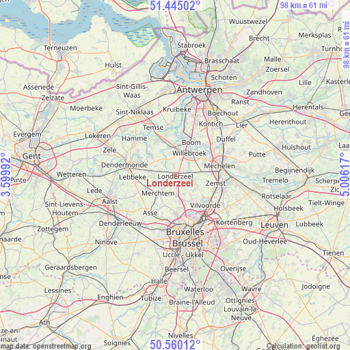
Londerzeel GPS coordinates[2]
51° 0' 16.848" North, 4° 18' 10.944" East
| Map corner | latitude | longitude |
|---|---|---|
| Upper-left | 51.44502°, | 3.59992° |
| Center: | 51.00468°, | 4.30304° |
| Lower-right: | 50.56012°, | 5.00617° |
| Map W x H: | 98.4×98.4 km | = 61.1×61.1mi |
| max Lat: | 51.46791° ⇑28.9% North |
| Londerzeel: | 51.00468° |
| min Lat: | ⇓71.1% South 49.53771° |
| min Long | Londerzeel | max Long |
| 2.59368° | 4.30304° | 6.25749° |
| W 35.7%⇐ | ⇒64.3% E |
Elevation
Elevation of Londerzeel is 12 m = 39 ft, and this is 87.5 m = 287 ft below average elevation for this country.
| Max E: |
582 m = 1909 ft | 82.3% |
| Avg. | 99.5 m = 326 ft | |
| Londerzeel | 12 m = 39 ft | |
Min E: |
1 m = 3 ft | 17.7% |
See also: Belgium elevation on elevation.city.
Geographical zone
Londerzeel is located in North temperate zone (between Tropic of Cancer and the Arctic Circle). Distance of this North polar circle is 1730 km =1075 mi to North.| Distance of | km | miles | from Londerzeel |
|---|---|---|---|
| North Pole | 4335.9 | 2694.2 | to North |
| Arctic Circle | 1730 | 1075 | to North |
| Tropic Cancer | 3065.3 | 1904.7 | to South |
| Equator | 5671.2 | 3523.9 | to South |


Nearby cities:
15 places around Londerzeel: (largest is in red/bold)
• Bever
9.8 km =6.1 mi,  174°
174°
• Boom
10.9 km =6.8 mi,  26°
26°
• Bornem
11.1 km =6.9 mi,  338°
338°
• Buggenhout
7.2 km =4.5 mi,  279°
279°
• Grimbergen
9.2 km =5.7 mi,  148°
148°
• Kapelle-op-den-Bos
4.2 km =2.6 mi,  82°
82°
• Lebbeke
11.8 km =7.3 mi,  269°
269°
• Meise
7.4 km =4.6 mi, 167°
• Merchtem
7.7 km =4.8 mi,  219°
219°
• Opwijk
9.3 km =5.8 mi,  243°
243°
• Puurs
7.8 km =4.8 mi,  352°
352°
• Sint-Amands
8.7 km =5.4 mi,  311°
311°
• Wemmel
10.7 km =6.6 mi,  178°
178°
• Willebroek
7.4 km =4.6 mi, 32°
• Zemst
11.3 km =7 mi,  102°
102°
Sources, notices
• [Note1] Compared only with cities in Belgium existing in our database
• [Src1] Map data: © OpenStreetMap contributors (CC-BY-SA)
• [Src2] Other city data from geonames.org with taken over terms of usage.
• [Src3] Geographical zone / Annual Mean Temperature by Robert A. Rohde @ Wikipedia
