Kapelle-op-den-Bos geodata
Kapelle-op-den-Bos (Flanders) is a populated place; located in Belgium in Europe/Brussels (GMT+2) time zone. With population of 8,859 people, there are 340 cities with bigger population in this country. Compared to other cities in Belgium, 71.8% of cities are located further ↓South; 61% of cities are located further →East and 82.3% of cities have higher elevation than Kapelle-op-den-Bos. Note1
Administrative division(s):
- Level 1: Flanders
- Level 2: Provincie Vlaams-Brabant
- Level 3: Arrondissement Halle-Vilvoorde
- Level 4: Kapelle-op-den-Bos


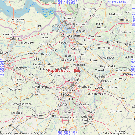
Kapelle-op-den-Bos GPS coordinates[2]
51° 0' 34.92" North, 4° 21' 46.908" East
| Map corner | latitude | longitude |
|---|---|---|
| Upper-left | 51.44999°, | 3.65991° |
| Center: | 51.0097°, | 4.36303° |
| Lower-right: | 50.56519°, | 5.06616° |
| Map W x H: | 98.4×98.4 km | = 61.1×61.1mi |
| max Lat: | 51.46791° ⇑28.2% North |
| Kapelle-op-den-Bos: | 51.0097° |
| min Lat: | ⇓71.8% South 49.53771° |
| min Long | Kapelle-op-den- | max Long |
| 2.59368° | 4.36303° | 6.25749° |
| W 39%⇐ | ⇒61% E |
Elevation
Elevation of Kapelle-op-den-Bos is 12 m = 39 ft, and this is 87.5 m = 287 ft below average elevation for this country.
| Max E: |
582 m = 1909 ft | 82.3% |
| Avg. | 99.5 m = 326 ft | |
| Kapelle-op-den-Bos | 12 m = 39 ft | |
Min E: |
1 m = 3 ft | 17.7% |
See also: Belgium elevation on elevation.city.
Geographical zone
Kapelle-op-den-Bos is located in North temperate zone (between Tropic of Cancer and the Arctic Circle). Distance of this North polar circle is 1729.4 km =1074.6 mi to North.| Distance of | km | miles | from Kapelle-op-den-Bos |
|---|---|---|---|
| North Pole | 4335.3 | 2693.8 | to North |
| Arctic Circle | 1729.4 | 1074.6 | to North |
| Tropic Cancer | 3065.8 | 1905 | to South |
| Equator | 5671.7 | 3524.2 | to South |


Nearby cities:
15 places around Kapelle-op-den-Bos: (largest is in red/bold)
• Bever
10.8 km =6.7 mi,  197°
197°
• Boom
9.2 km =5.7 mi,  3°
3°
• Buggenhout
11.3 km =7 mi,  273°
273°
• Grimbergen
8.4 km =5.2 mi,  175°
175°
• Londerzeel
4.2 km =2.6 mi,  262°
262°
• Mechelen
8.2 km =5.1 mi,  77°
77°
• Meise
8.2 km =5.1 mi, 198°
• Merchtem
11.2 km =7 mi,  234°
234°
• Niel
11.4 km =7.1 mi,  349°
349°
• Puurs
8.9 km =5.5 mi,  323°
323°
• Rumst
9 km =5.6 mi,  27°
27°
• Sint-Amands
11.9 km =7.4 mi,  295°
295°
• Vilvoorde
10.2 km =6.3 mi,  152°
152°
• Willebroek
5.6 km =3.5 mi,  357°
357°
• Zemst
7.4 km =4.6 mi,  113°
113°
In other languages:
- In France: Chapelle-au-Bois
- In Russian: Капелле-оп-ден-Бос
- In Chinese: 卡佩尔-奥普-登-博斯
Sources, notices
• [Note1] Compared only with cities in Belgium existing in our database
• [Src1] Map data: © OpenStreetMap contributors (CC-BY-SA)
• [Src2] Other city data from geonames.org with taken over terms of usage.
• [Src3] Geographical zone / Annual Mean Temperature by Robert A. Rohde @ Wikipedia
