Verlaine geodata
Verlaine (Wallonia) is a populated place; located in Belgium in Europe/Brussels (GMT+2) time zone. With population of 3,600 people, there are 492 cities with bigger population in this country. Compared to other cities in Belgium, 68.4% of cities are located further ↑North; 77.6% of cities are located further ←West and 79.2% of cities have lower elevation than Verlaine. Note1
Administrative division(s):
- Level 1: Wallonia
- Level 2: Province de Liège
- Level 3: Arrondissement de Huy
- Level 4: Verlaine


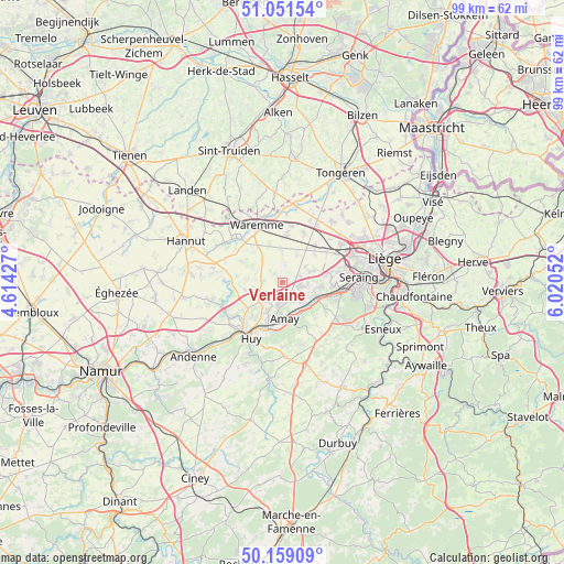
Verlaine GPS coordinates[2]
50° 36' 26.748" North, 5° 19' 2.64" East
| Map corner | latitude | longitude |
|---|---|---|
| Upper-left | 51.05154°, | 4.61427° |
| Center: | 50.60743°, | 5.3174° |
| Lower-right: | 50.15909°, | 6.02052° |
| Map W x H: | 99.2×99.2 km | = 61.6×61.6mi |
| max Lat: | 51.46791° ⇑68.4% North |
| Verlaine: | 50.60743° |
| min Lat: | ⇓31.6% South 49.53771° |
| min Long | Verlaine | max Long |
| 2.59368° | 5.3174° | 6.25749° |
| W 77.6%⇐ | ⇒22.4% E |
Elevation
Elevation of Verlaine is 171 m = 561 ft, and this is 71.5 m = 235 ft above average elevation for this country.
| Max E: |
582 m = 1909 ft | 20.8% |
| Verlaine | 171 m 561 ft | |
| Avg. | 99.5 m = 326 ft | |
Min E: |
1 m = 3 ft | 79.2% |
See also: Belgium elevation on elevation.city.
Geographical zone
Verlaine is located in North temperate zone (between Tropic of Cancer and the Arctic Circle). Distance of this North polar circle is 1774.2 km =1102.4 mi to North.| Distance of | km | miles | from Verlaine |
|---|---|---|---|
| North Pole | 4380 | 2721.6 | to North |
| Arctic Circle | 1774.2 | 1102.4 | to North |
| Tropic Cancer | 3021.1 | 1877.2 | to South |
| Equator | 5627 | 3496.5 | to South |


Nearby cities:
15 places around Verlaine: (largest is in red/bold)
• Amay
6.6 km =4.1 mi,  184°
184°
• Awans
12.3 km =7.6 mi,  56°
56°
• Donceel
4.5 km =2.8 mi,  2°
2°
• Engis
6.4 km =4 mi,  116°
116°
• Faimes
7.3 km =4.5 mi,  326°
326°
• Fexhe-le-Haut-Clocher
8.7 km =5.4 mi,  42°
42°
• Flémalle-Haute
9 km =5.6 mi,  95°
95°
• Geer
12.3 km =7.6 mi,  304°
304°
• Huy
11.5 km =7.1 mi,  211°
211°
• Mons-lez-Liège
10.6 km =6.6 mi,  84°
84°
• Oreye
12.4 km =7.7 mi,  10°
10°
• Remicourt
8.2 km =5.1 mi, 5°
• Villers-le-Bouillet
5.3 km =3.3 mi,  230°
230°
• Wanze
10.8 km =6.7 mi, 225°
• Waremme
10.9 km =6.8 mi,  336°
336°
Sources, notices
• [Note1] Compared only with cities in Belgium existing in our database
• [Src1] Map data: © OpenStreetMap contributors (CC-BY-SA)
• [Src2] Other city data from geonames.org with taken over terms of usage.
• [Src3] Geographical zone / Annual Mean Temperature by Robert A. Rohde @ Wikipedia
