Huy geodata
Huy (Wallonia) is a populated place; located in Belgium in Europe/Brussels (GMT+2) time zone. With population of 19,973 people, there are 123 cities with bigger population in this country. Compared to other cities in Belgium, 75.8% of cities are located further ↑North; 74.2% of cities are located further ←West and 58.7% of cities have lower elevation than Huy. Note1
Administrative division(s):
- Level 1: Wallonia
- Level 2: Province de Liège
- Level 3: Arrondissement de Huy
- Level 4: Huy


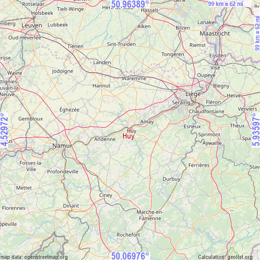
Huy GPS coordinates[2]
50° 31' 8.184" North, 5° 13' 58.224" East
| Map corner | latitude | longitude |
|---|---|---|
| Upper-left | 50.96389°, | 4.52972° |
| Center: | 50.51894°, | 5.23284° |
| Lower-right: | 50.06976°, | 5.93597° |
| Map W x H: | 99.4×99.4 km | = 61.8×61.8mi |
| max Lat: | 51.46791° ⇑75.8% North |
| Huy: | 50.51894° |
| min Lat: | ⇓24.2% South 49.53771° |
| min Long | Huy | max Long |
| 2.59368° | 5.23284° | 6.25749° |
| W 74.2%⇐ | ⇒25.8% E |
Elevation
Elevation of Huy is 75 m = 246 ft, and this is 24.5 m = 80 ft below average elevation for this country.
| Max E: |
582 m = 1909 ft | 41.3% |
| Avg. | 99.5 m = 326 ft | |
| Huy | 75 m = 246 ft | |
Min E: |
1 m = 3 ft | 58.7% |
See also: Belgium elevation on elevation.city.
Geographical zone
Huy is located in North temperate zone (between Tropic of Cancer and the Arctic Circle). Distance of this North polar circle is 1784 km =1108.5 mi to North.| Distance of | km | miles | from Huy |
|---|---|---|---|
| North Pole | 4389.9 | 2727.8 | to North |
| Arctic Circle | 1784 | 1108.5 | to North |
| Tropic Cancer | 3011.3 | 1871.1 | to South |
| Equator | 5617.2 | 3490.4 | to South |


Nearby cities:
15 places around Huy: (largest is in red/bold)
• Amay
6.3 km =3.9 mi,  59°
59°
• Andenne
10.3 km =6.4 mi,  251°
251°
• Braives
13 km =8.1 mi,  327°
327°
• Burdinne
13.2 km =8.2 mi,  303°
303°
• Engis
13.7 km =8.5 mi, 59°
• Havelange
14.4 km =8.9 mi,  178°
178°
• Héron
10.1 km =6.3 mi,  288°
288°
• Marchin
5.8 km =3.6 mi,  173°
173°
• Modave
9.2 km =5.7 mi,  151°
151°
• Nandrin
13.2 km =8.2 mi,  95°
95°
• Ohey
12.1 km =7.5 mi,  219°
219°
• Tinlot
11.3 km =7 mi,  115°
115°
• Verlaine
11.5 km =7.1 mi,  31°
31°
• Villers-le-Bouillet
6.7 km =4.2 mi,  16°
16°
• Wanze
2.8 km =1.7 mi,  322°
322°
Sources, notices
• [Note1] Compared only with cities in Belgium existing in our database
• [Src1] Map data: © OpenStreetMap contributors (CC-BY-SA)
• [Src2] Other city data from geonames.org with taken over terms of usage.
• [Src3] Geographical zone / Annual Mean Temperature by Robert A. Rohde @ Wikipedia
