Aubel geodata
Aubel (Wallonia) is a populated place; located in Belgium in Europe/Brussels (GMT+2) time zone. With population of 4,119 people, there are 482 cities with bigger population in this country. Compared to other cities in Belgium, 58.8% of cities are located further ↑North; 96.2% of cities are located further ←West and 85.7% of cities have lower elevation than Aubel. Note1
Administrative division(s):
- Level 1: Wallonia
- Level 2: Province de Liège
- Level 3: Arrondissement de Verviers
- Level 4: Aubel


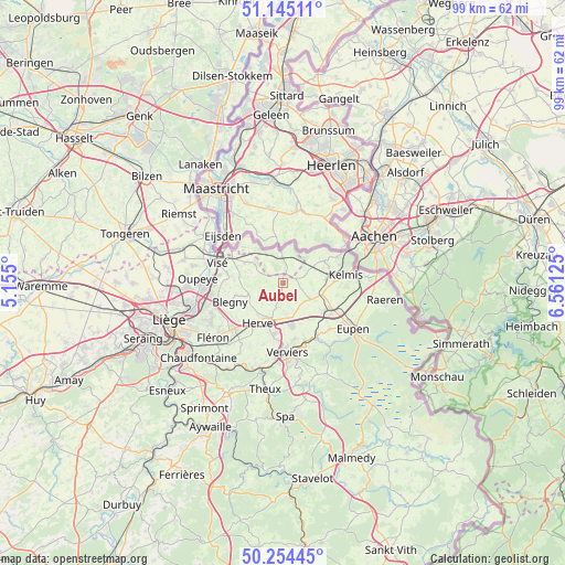
Aubel GPS coordinates[2]
50° 42' 6.804" North, 5° 51' 29.232" East
| Map corner | latitude | longitude |
|---|---|---|
| Upper-left | 51.14511°, | 5.155° |
| Center: | 50.70189°, | 5.85812° |
| Lower-right: | 50.25445°, | 6.56125° |
| Map W x H: | 99×99 km | = 61.5×61.5mi |
| max Lat: | 51.46791° ⇑58.8% North |
| Aubel: | 50.70189° |
| min Lat: | ⇓41.2% South 49.53771° |
| min Long | Aubel | max Long |
| 2.59368° | 5.85812° | 6.25749° |
| W 96.2%⇐ | ⇒3.8% E |
Elevation
Elevation of Aubel is 226 m = 741 ft, and this is 126.5 m = 415 ft above average elevation for this country.
| Max E: |
582 m = 1909 ft | 14.3% |
| Aubel | 226 m 741 ft | |
| Avg. | 99.5 m = 326 ft | |
Min E: |
1 m = 3 ft | 85.7% |
See also: Belgium elevation on elevation.city.
Geographical zone
Aubel is located in North temperate zone (between Tropic of Cancer and the Arctic Circle). Distance of this North polar circle is 1763.7 km =1095.9 mi to North.| Distance of | km | miles | from Aubel |
|---|---|---|---|
| North Pole | 4369.5 | 2715.1 | to North |
| Arctic Circle | 1763.7 | 1095.9 | to North |
| Tropic Cancer | 3031.6 | 1883.7 | to South |
| Equator | 5637.5 | 3503 | to South |


Nearby cities:
15 places around Aubel: (largest is in red/bold)
• Baelen
11.3 km =7 mi,  133°
133°
• Blégny
9.9 km =6.2 mi,  250°
250°
• Dalhem
9.3 km =5.8 mi,  277°
277°
• Dison
10.2 km =6.3 mi,  181°
181°
• Herve
8.2 km =5.1 mi,  213°
213°
• La Calamine
10.9 km =6.8 mi,  80°
80°
• Limbourg
11.6 km =7.2 mi,  149°
149°
• Lontzen
10.7 km =6.6 mi,  102°
102°
• Pepinster
14.7 km =9.1 mi,  194°
194°
• Plombières
8.1 km =5 mi,  61°
61°
• Sint-Pieters-Voeren
4.8 km =3 mi,  328°
328°
• Soumagne
12.5 km =7.8 mi,  218°
218°
• Verviers
12.5 km =7.8 mi, 178°
• Visé
11.9 km =7.4 mi,  289°
289°
• Welkenraedt
9.1 km =5.7 mi,  120°
120°
Sources, notices
• [Note1] Compared only with cities in Belgium existing in our database
• [Src1] Map data: © OpenStreetMap contributors (CC-BY-SA)
• [Src2] Other city data from geonames.org with taken over terms of usage.
• [Src3] Geographical zone / Annual Mean Temperature by Robert A. Rohde @ Wikipedia
