Clavier geodata
Clavier (Wallonia) is a populated place; located in Belgium in Europe/Brussels (GMT+2) time zone. With population of 4,092 people, there are 484 cities with bigger population in this country. Compared to other cities in Belgium, 84.8% of cities are located further ↑North; 79.4% of cities are located further ←West and 91.9% of cities have lower elevation than Clavier. Note1
Administrative division(s):
- Level 1: Wallonia
- Level 2: Province de Liège
- Level 3: Arrondissement de Huy
- Level 4: Clavier


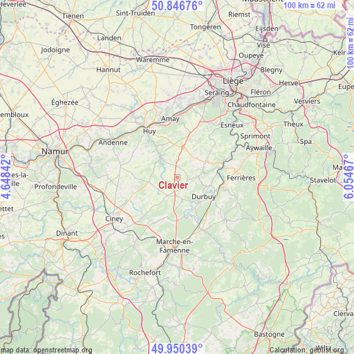
Clavier GPS coordinates[2]
50° 24' 2.484" North, 5° 21' 5.544" East
| Map corner | latitude | longitude |
|---|---|---|
| Upper-left | 50.84676°, | 4.64842° |
| Center: | 50.40069°, | 5.35154° |
| Lower-right: | 49.95039°, | 6.05467° |
| Map W x H: | 99.7×99.7 km | = 62×62mi |
| max Lat: | 51.46791° ⇑84.8% North |
| Clavier: | 50.40069° |
| min Lat: | ⇓15.2% South 49.53771° |
| min Long | Clavier | max Long |
| 2.59368° | 5.35154° | 6.25749° |
| W 79.4%⇐ | ⇒20.6% E |
Elevation
Elevation of Clavier is 295 m = 968 ft, and this is 195.5 m = 641 ft above average elevation for this country.
| Max E: |
582 m = 1909 ft | 8.1% |
| Clavier | 295 m 968 ft | |
| Avg. | 99.5 m = 326 ft | |
Min E: |
1 m = 3 ft | 91.9% |
See also: Belgium elevation on elevation.city.
Geographical zone
Clavier is located in North temperate zone (between Tropic of Cancer and the Arctic Circle). Distance of this North polar circle is 1797.1 km =1116.7 mi to North.| Distance of | km | miles | from Clavier |
|---|---|---|---|
| North Pole | 4403 | 2735.9 | to North |
| Arctic Circle | 1797.1 | 1116.7 | to North |
| Tropic Cancer | 2998.1 | 1862.9 | to South |
| Equator | 5604 | 3482.2 | to South |


Nearby cities:
15 places around Clavier: (largest is in red/bold)
• Amay
16.7 km =10.4 mi,  349°
349°
• Anthisnes
15 km =9.3 mi,  52°
52°
• Durbuy
9.1 km =5.7 mi,  125°
125°
• Hamoir
13.2 km =8.2 mi,  77°
77°
• Hamois
15.4 km =9.6 mi,  244°
244°
• Havelange
8.1 km =5 mi,  261°
261°
• Hotton
16.3 km =10.1 mi,  155°
155°
• Huy
15.6 km =9.7 mi,  327°
327°
• Marchin
10.7 km =6.6 mi,  313°
313°
• Modave
6.4 km =4 mi,  321°
321°
• Nandrin
12.7 km =7.9 mi,  22°
22°
• Ohey
16.6 km =10.3 mi,  283°
283°
• Ouffet
9.1 km =5.7 mi,  62°
62°
• Somme-Leuze
7.2 km =4.5 mi,  171°
171°
• Tinlot
8.5 km =5.3 mi,  12°
12°
Sources, notices
• [Note1] Compared only with cities in Belgium existing in our database
• [Src1] Map data: © OpenStreetMap contributors (CC-BY-SA)
• [Src2] Other city data from geonames.org with taken over terms of usage.
• [Src3] Geographical zone / Annual Mean Temperature by Robert A. Rohde @ Wikipedia
