Beyne-Heusay geodata
Beyne-Heusay (Wallonia) is a populated place; located in Belgium in Europe/Brussels (GMT+2) time zone. With population of 11,608 people, there are 255 cities with bigger population in this country. Compared to other cities in Belgium, 66.4% of cities are located further ↑North; 91% of cities are located further ←West and 86.6% of cities have lower elevation than Beyne-Heusay. Note1
Administrative division(s):
- Level 1: Wallonia
- Level 2: Province de Liège
- Level 3: Arrondissement de Liège
- Level 4: Beyne-Heusay


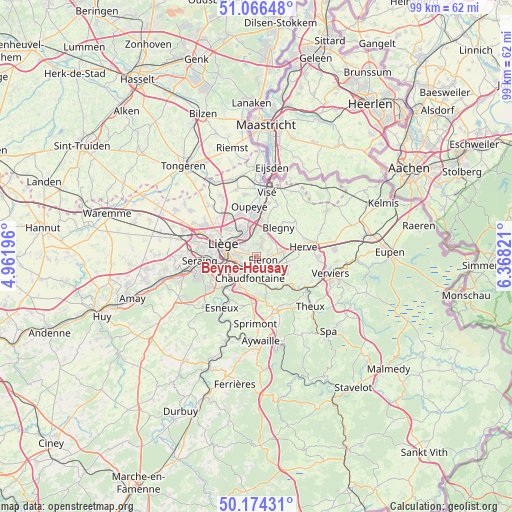
Beyne-Heusay GPS coordinates[2]
50° 37' 21.036" North, 5° 39' 54.288" East
| Map corner | latitude | longitude |
|---|---|---|
| Upper-left | 51.06648°, | 4.96196° |
| Center: | 50.62251°, | 5.66508° |
| Lower-right: | 50.17431°, | 6.36821° |
| Map W x H: | 99.2×99.2 km | = 61.6×61.6mi |
| max Lat: | 51.46791° ⇑66.4% North |
| Beyne-Heusay: | 50.62251° |
| min Lat: | ⇓33.6% South 49.53771° |
| min Long | Beyne-Heusay | max Long |
| 2.59368° | 5.66508° | 6.25749° |
| W 91%⇐ | ⇒9% E |
Elevation
Elevation of Beyne-Heusay is 231 m = 758 ft, and this is 131.5 m = 431 ft above average elevation for this country.
| Max E: |
582 m = 1909 ft | 13.4% |
| Beyne-Heusay | 231 m 758 ft | |
| Avg. | 99.5 m = 326 ft | |
Min E: |
1 m = 3 ft | 86.6% |
See also: Belgium elevation on elevation.city.
Geographical zone
Beyne-Heusay is located in North temperate zone (between Tropic of Cancer and the Arctic Circle). Distance of this North polar circle is 1772.5 km =1101.4 mi to North.| Distance of | km | miles | from Beyne-Heusay |
|---|---|---|---|
| North Pole | 4378.4 | 2720.6 | to North |
| Arctic Circle | 1772.5 | 1101.4 | to North |
| Tropic Cancer | 3022.8 | 1878.3 | to South |
| Equator | 5628.7 | 3497.5 | to South |


Nearby cities:
15 places around Beyne-Heusay: (largest is in red/bold)
• Ans
11.1 km =6.9 mi,  293°
293°
• Blégny
7 km =4.3 mi,  37°
37°
• Chaudfontaine
4.9 km =3 mi,  206°
206°
• Dalhem
11 km =6.8 mi,  23°
23°
• Esneux
11.8 km =7.3 mi,  215°
215°
• Fléron
1.4 km =0.9 mi,  126°
126°
• Herstal
5.5 km =3.4 mi,  327°
327°
• Herve
9.3 km =5.8 mi,  77°
77°
• Liège
7 km =4.3 mi,  280°
280°
• Olne
6.8 km =4.2 mi,  122°
122°
• Oupeye
10 km =6.2 mi,  352°
352°
• Pepinster
11.3 km =7 mi, 118°
• Saint-Nicolas
9.4 km =5.8 mi,  273°
273°
• Soumagne
5.8 km =3.6 mi,  99°
99°
• Trooz
6.2 km =3.9 mi,  159°
159°
Sources, notices
• [Note1] Compared only with cities in Belgium existing in our database
• [Src1] Map data: © OpenStreetMap contributors (CC-BY-SA)
• [Src2] Other city data from geonames.org with taken over terms of usage.
• [Src3] Geographical zone / Annual Mean Temperature by Robert A. Rohde @ Wikipedia
