Blégny geodata
Blégny (Wallonia) is a populated place; located in Belgium in Europe/Brussels (GMT+2) time zone. With population of 12,745 people, there are 232 cities with bigger population in this country. Compared to other cities in Belgium, 61.4% of cities are located further ↑North; 92.8% of cities are located further ←West and 83.9% of cities have lower elevation than Blégny. Note1
Administrative division(s):
- Level 1: Wallonia
- Level 2: Province de Liège
- Level 3: Arrondissement de Liège
- Level 4: Blégny


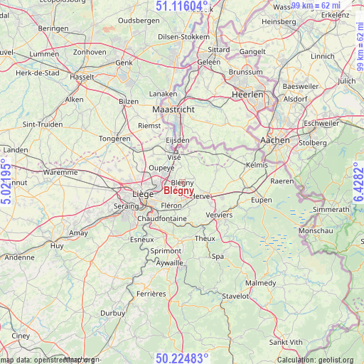
Blégny GPS coordinates[2]
50° 40' 21.18" North, 5° 43' 30.288" East
| Map corner | latitude | longitude |
|---|---|---|
| Upper-left | 51.11604°, | 5.02195° |
| Center: | 50.67255°, | 5.72508° |
| Lower-right: | 50.22483°, | 6.4282° |
| Map W x H: | 99.1×99.1 km | = 61.6×61.6mi |
| max Lat: | 51.46791° ⇑61.4% North |
| Blégny: | 50.67255° |
| min Lat: | ⇓38.6% South 49.53771° |
| min Long | Blégny | max Long |
| 2.59368° | 5.72508° | 6.25749° |
| W 92.8%⇐ | ⇒7.2% E |
Elevation
Elevation of Blégny is 218 m = 715 ft, and this is 118.5 m = 389 ft above average elevation for this country.
| Max E: |
582 m = 1909 ft | 16.1% |
| Blégny | 218 m 715 ft | |
| Avg. | 99.5 m = 326 ft | |
Min E: |
1 m = 3 ft | 83.9% |
See also: Belgium elevation on elevation.city.
Geographical zone
Blégny is located in North temperate zone (between Tropic of Cancer and the Arctic Circle). Distance of this North polar circle is 1766.9 km =1097.9 mi to North.| Distance of | km | miles | from Blégny |
|---|---|---|---|
| North Pole | 4372.8 | 2717.1 | to North |
| Arctic Circle | 1766.9 | 1097.9 | to North |
| Tropic Cancer | 3028.3 | 1881.7 | to South |
| Equator | 5634.3 | 3501 | to South |


Nearby cities:
15 places around Blégny: (largest is in red/bold)
• Aubel
9.9 km =6.2 mi,  70°
70°
• Beyne-Heusay
7 km =4.3 mi,  217°
217°
• Chaudfontaine
11.9 km =7.4 mi,  212°
212°
• Dalhem
4.5 km =2.8 mi,  2°
2°
• Dison
11.4 km =7.1 mi,  127°
127°
• Fléron
7.1 km =4.4 mi, 206°
• Herstal
7.2 km =4.5 mi,  262°
262°
• Herve
6 km =3.7 mi, 126°
• Liège
11.9 km =7.4 mi,  248°
248°
• Olne
9.3 km =5.8 mi,  170°
170°
• Oupeye
7 km =4.3 mi,  308°
308°
• Sint-Pieters-Voeren
10 km =6.2 mi,  42°
42°
• Soumagne
6.7 km =4.2 mi, 166°
• Trooz
11.6 km =7.2 mi,  190°
190°
• Visé
7.5 km =4.7 mi,  345°
345°
Sources, notices
• [Note1] Compared only with cities in Belgium existing in our database
• [Src1] Map data: © OpenStreetMap contributors (CC-BY-SA)
• [Src2] Other city data from geonames.org with taken over terms of usage.
• [Src3] Geographical zone / Annual Mean Temperature by Robert A. Rohde @ Wikipedia
