Nandrin geodata
Nandrin (Wallonia) is a populated place; located in Belgium in Europe/Brussels (GMT+2) time zone. With population of 5,480 people, there are 436 cities with bigger population in this country. Compared to other cities in Belgium, 76.4% of cities are located further ↑North; 81.8% of cities are located further ←West and 83.9% of cities have lower elevation than Nandrin. Note1
Administrative division(s):
- Level 1: Wallonia
- Level 2: Province de Liège
- Level 3: Arrondissement de Huy
- Level 4: Nandrin


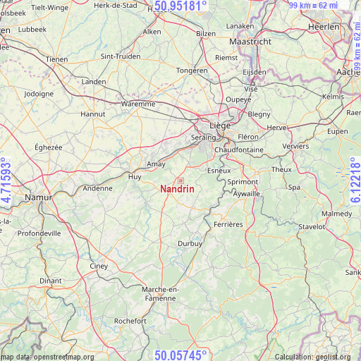
Nandrin GPS coordinates[2]
50° 30' 24.3" North, 5° 25' 8.58" East
| Map corner | latitude | longitude |
|---|---|---|
| Upper-left | 50.95181°, | 4.71593° |
| Center: | 50.50675°, | 5.41905° |
| Lower-right: | 50.05745°, | 6.12218° |
| Map W x H: | 99.4×99.4 km | = 61.8×61.8mi |
| max Lat: | 51.46791° ⇑76.4% North |
| Nandrin: | 50.50675° |
| min Lat: | ⇓23.6% South 49.53771° |
| min Long | Nandrin | max Long |
| 2.59368° | 5.41905° | 6.25749° |
| W 81.8%⇐ | ⇒18.2% E |
Elevation
Elevation of Nandrin is 218 m = 715 ft, and this is 118.5 m = 389 ft above average elevation for this country.
| Max E: |
582 m = 1909 ft | 16.1% |
| Nandrin | 218 m 715 ft | |
| Avg. | 99.5 m = 326 ft | |
Min E: |
1 m = 3 ft | 83.9% |
See also: Belgium elevation on elevation.city.
Geographical zone
Nandrin is located in North temperate zone (between Tropic of Cancer and the Arctic Circle). Distance of this North polar circle is 1785.3 km =1109.3 mi to North.| Distance of | km | miles | from Nandrin |
|---|---|---|---|
| North Pole | 4391.2 | 2728.6 | to North |
| Arctic Circle | 1785.3 | 1109.3 | to North |
| Tropic Cancer | 3009.9 | 1870.3 | to South |
| Equator | 5615.8 | 3489.5 | to South |


Nearby cities:
15 places around Nandrin: (largest is in red/bold)
• Amay
9 km =5.6 mi,  300°
300°
• Anthisnes
7.5 km =4.7 mi,  110°
110°
• Clavier
12.7 km =7.9 mi,  202°
202°
• Comblain-au-Pont
11.7 km =7.3 mi, 107°
• Engis
8.4 km =5.2 mi,  350°
350°
• Esneux
11 km =6.8 mi,  72°
72°
• Flémalle-Haute
10.5 km =6.5 mi,  9°
9°
• Hamoir
12 km =7.5 mi,  137°
137°
• Huy
13.2 km =8.2 mi,  275°
275°
• Marchin
13.2 km =8.2 mi,  250°
250°
• Modave
11 km =6.8 mi,  232°
232°
• Mons-lez-Liège
12.7 km =7.9 mi,  15°
15°
• Ouffet
8.3 km =5.2 mi,  156°
156°
• Seraing
10.3 km =6.4 mi,  34°
34°
• Tinlot
4.6 km =2.9 mi,  219°
219°
Sources, notices
• [Note1] Compared only with cities in Belgium existing in our database
• [Src1] Map data: © OpenStreetMap contributors (CC-BY-SA)
• [Src2] Other city data from geonames.org with taken over terms of usage.
• [Src3] Geographical zone / Annual Mean Temperature by Robert A. Rohde @ Wikipedia
