Seraing geodata
Seraing (Wallonia) is a populated place; located in Belgium in Europe/Brussels (GMT+2) time zone. With population of 60,737 people, there are 19 cities with bigger population in this country. Compared to other cities in Belgium, 70.6% of cities are located further ↑North; 84.5% of cities are located further ←West and 81% of cities have lower elevation than Seraing. Note1
Administrative division(s):
- Level 1: Wallonia
- Level 2: Province de Liège
- Level 3: Arrondissement de Liège
- Level 4: Seraing


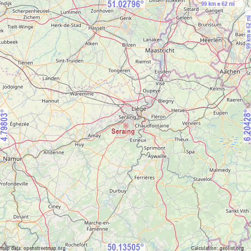
Seraing GPS coordinates[2]
50° 35' 1.032" North, 5° 30' 4.14" East
| Map corner | latitude | longitude |
|---|---|---|
| Upper-left | 51.02796°, | 4.79803° |
| Center: | 50.58362°, | 5.50115° |
| Lower-right: | 50.13505°, | 6.20428° |
| Map W x H: | 99.3×99.3 km | = 61.7×61.7mi |
| max Lat: | 51.46791° ⇑70.6% North |
| Seraing: | 50.58362° |
| min Lat: | ⇓29.4% South 49.53771° |
| min Long | Seraing | max Long |
| 2.59368° | 5.50115° | 6.25749° |
| W 84.5%⇐ | ⇒15.5% E |
Elevation
Elevation of Seraing is 185 m = 607 ft, and this is 85.5 m = 281 ft above average elevation for this country.
| Max E: |
582 m = 1909 ft | 19% |
| Seraing | 185 m 607 ft | |
| Avg. | 99.5 m = 326 ft | |
Min E: |
1 m = 3 ft | 81% |
See also: Seraing elevation on elevation.city.
Geographical zone
Seraing is located in North temperate zone (between Tropic of Cancer and the Arctic Circle). Distance of this North polar circle is 1776.8 km =1104.1 mi to North.| Distance of | km | miles | from Seraing |
|---|---|---|---|
| North Pole | 4382.7 | 2723.3 | to North |
| Arctic Circle | 1776.8 | 1104.1 | to North |
| Tropic Cancer | 3018.5 | 1875.6 | to South |
| Equator | 5624.4 | 3494.8 | to South |


Nearby cities:
15 places around Seraing: (largest is in red/bold)
• Ans
8.9 km =5.5 mi,  8°
8°
• Anthisnes
11.2 km =7 mi,  173°
173°
• Awans
9.7 km =6 mi,  344°
344°
• Beyne-Heusay
12.4 km =7.7 mi,  69°
69°
• Chaudfontaine
9.4 km =5.8 mi,  90°
90°
• Engis
7.2 km =4.5 mi,  268°
268°
• Esneux
7.1 km =4.4 mi,  138°
138°
• Fexhe-le-Haut-Clocher
11.6 km =7.2 mi,  321°
321°
• Flémalle-Haute
4.4 km =2.7 mi,  294°
294°
• Fléron
13.1 km =8.1 mi, 74°
• Herstal
12.4 km =7.7 mi,  43°
43°
• Liège
7.3 km =4.5 mi, 40°
• Mons-lez-Liège
4.4 km =2.7 mi,  326°
326°
• Nandrin
10.3 km =6.4 mi,  214°
214°
• Saint-Nicolas
5.4 km =3.4 mi,  23°
23°
Sources, notices
• [Note1] Compared only with cities in Belgium existing in our database
• [Src1] Map data: © OpenStreetMap contributors (CC-BY-SA)
• [Src2] Other city data from geonames.org with taken over terms of usage.
• [Src3] Geographical zone / Annual Mean Temperature by Robert A. Rohde @ Wikipedia
