Esneux geodata
Esneux (Wallonia) is a populated place; located in Belgium in Europe/Brussels (GMT+2) time zone. With population of 13,497 people, there are 218 cities with bigger population in this country. Compared to other cities in Belgium, 74.5% of cities are located further ↑North; 87.2% of cities are located further ←West and 68.6% of cities have lower elevation than Esneux. Note1
Administrative division(s):
- Level 1: Wallonia
- Level 2: Province de Liège
- Level 3: Arrondissement de Liège
- Level 4: Esneux


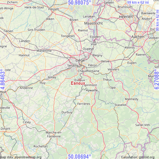
Esneux GPS coordinates[2]
50° 32' 9.456" North, 5° 34' 3.9" East
| Map corner | latitude | longitude |
|---|---|---|
| Upper-left | 50.98075°, | 4.86463° |
| Center: | 50.53596°, | 5.56775° |
| Lower-right: | 50.08694°, | 6.27088° |
| Map W x H: | 99.4×99.4 km | = 61.8×61.8mi |
| max Lat: | 51.46791° ⇑74.5% North |
| Esneux: | 50.53596° |
| min Lat: | ⇓25.5% South 49.53771° |
| min Long | Esneux | max Long |
| 2.59368° | 5.56775° | 6.25749° |
| W 87.2%⇐ | ⇒12.8% E |
Elevation
Elevation of Esneux is 115 m = 377 ft, and this is 15.5 m = 51 ft above average elevation for this country.
| Max E: |
582 m = 1909 ft | 31.4% |
| Esneux | 115 m 377 ft | |
| Avg. | 99.5 m = 326 ft | |
Min E: |
1 m = 3 ft | 68.6% |
See also: Belgium elevation on elevation.city.
Geographical zone
Esneux is located in North temperate zone (between Tropic of Cancer and the Arctic Circle). Distance of this North polar circle is 1782.1 km =1107.3 mi to North.| Distance of | km | miles | from Esneux |
|---|---|---|---|
| North Pole | 4388 | 2726.6 | to North |
| Arctic Circle | 1782.1 | 1107.3 | to North |
| Tropic Cancer | 3013.2 | 1872.3 | to South |
| Equator | 5619.1 | 3491.5 | to South |


Nearby cities:
15 places around Esneux: (largest is in red/bold)
• Anthisnes
6.8 km =4.2 mi,  210°
210°
• Aywaille
10.3 km =6.4 mi,  131°
131°
• Beyne-Heusay
11.8 km =7.3 mi,  35°
35°
• Chaudfontaine
7 km =4.3 mi, 41°
• Comblain-au-Pont
6.8 km =4.2 mi,  174°
174°
• Flémalle-Haute
11.2 km =7 mi,  309°
309°
• Fléron
11.9 km =7.4 mi, 42°
• Hamoir
12.4 km =7.7 mi,  191°
191°
• Liège
10.9 km =6.8 mi,  359°
359°
• Mons-lez-Liège
11.5 km =7.1 mi,  321°
321°
• Nandrin
11 km =6.8 mi,  252°
252°
• Saint-Nicolas
10.6 km =6.6 mi,  346°
346°
• Seraing
7.1 km =4.4 mi, 318°
• Sprimont
7.1 km =4.4 mi,  114°
114°
• Trooz
9.8 km =6.1 mi,  67°
67°
Sources, notices
• [Note1] Compared only with cities in Belgium existing in our database
• [Src1] Map data: © OpenStreetMap contributors (CC-BY-SA)
• [Src2] Other city data from geonames.org with taken over terms of usage.
• [Src3] Geographical zone / Annual Mean Temperature by Robert A. Rohde @ Wikipedia
