Liège geodata
Liège (Wallonia) is a populated place; located in Belgium in Europe/Brussels (GMT+2) time zone. With population of 182,597 people, there are 4 cities with bigger population in this country. Compared to other cities in Belgium, 65.2% of cities are located further ↑North; 87% of cities are located further ←West and 57% of cities have lower elevation than Liège. Note1
Administrative division(s):
- Level 1: Wallonia
- Level 2: Province de Liège
- Level 3: Arrondissement de Liège
- Level 4: Liège


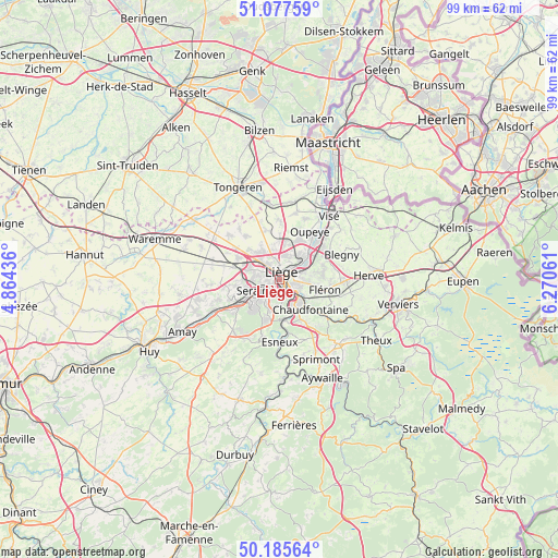
Liège GPS coordinates[2]
50° 38' 1.428" North, 5° 34' 2.964" East
| Map corner | latitude | longitude |
|---|---|---|
| Upper-left | 51.07759°, | 4.86436° |
| Center: | 50.63373°, | 5.56749° |
| Lower-right: | 50.18564°, | 6.27061° |
| Map W x H: | 99.2×99.2 km | = 61.6×61.6mi |
| max Lat: | 51.46791° ⇑65.2% North |
| Liège: | 50.63373° |
| min Lat: | ⇓34.8% South 49.53771° |
| min Long | Liège | max Long |
| 2.59368° | 5.56749° | 6.25749° |
| W 87%⇐ | ⇒13% E |
Elevation
Elevation of Liège is 66 m = 217 ft, and this is 33.5 m = 110 ft below average elevation for this country.
| Max E: |
582 m = 1909 ft | 43% |
| Avg. | 99.5 m = 326 ft | |
| Liège | 66 m = 217 ft | |
Min E: |
1 m = 3 ft | 57% |
See also: Liège elevation on elevation.city.
Geographical zone
Liège is located in North temperate zone (between Tropic of Cancer and the Arctic Circle). Distance of this North polar circle is 1771.2 km =1100.6 mi to North.| Distance of | km | miles | from Liège |
|---|---|---|---|
| North Pole | 4377.1 | 2719.8 | to North |
| Arctic Circle | 1771.2 | 1100.6 | to North |
| Tropic Cancer | 3024 | 1879 | to South |
| Equator | 5629.9 | 3498.3 | to South |


Nearby cities:
15 places around Liège: (largest is in red/bold)
• Ans
4.6 km =2.9 mi,  313°
313°
• Awans
8.3 km =5.2 mi,  297°
297°
• Beyne-Heusay
7 km =4.3 mi,  100°
100°
• Blégny
11.9 km =7.4 mi,  68°
68°
• Chaudfontaine
7.4 km =4.6 mi,  140°
140°
• Esneux
10.9 km =6.8 mi,  179°
179°
• Flémalle-Haute
9.4 km =5.8 mi,  246°
246°
• Fléron
8.2 km =5.1 mi, 104°
• Herstal
5.2 km =3.2 mi,  49°
49°
• Juprelle
8.6 km =5.3 mi,  342°
342°
• Mons-lez-Liège
7.4 km =4.6 mi,  255°
255°
• Oupeye
10.3 km =6.4 mi,  32°
32°
• Saint-Nicolas
2.5 km =1.6 mi, 256°
• Seraing
7.3 km =4.5 mi,  220°
220°
• Trooz
11.4 km =7.1 mi,  128°
128°
In other languages:
- In Spanish: Lieja
- In German: Lüttich
- In Italian: Liegi
- In Russian: Льеж
- In Chinese: 列日
Sources, notices
• [Note1] Compared only with cities in Belgium existing in our database
• [Src1] Map data: © OpenStreetMap contributors (CC-BY-SA)
• [Src2] Other city data from geonames.org with taken over terms of usage.
• [Src3] Geographical zone / Annual Mean Temperature by Robert A. Rohde @ Wikipedia
