Oupeye geodata
Oupeye (Wallonia) is a populated place; located in Belgium in Europe/Brussels (GMT+2) time zone. With population of 23,594 people, there are 88 cities with bigger population in this country. Compared to other cities in Belgium, 58.1% of cities are located further ↑North; 90.1% of cities are located further ←West and 70.6% of cities have lower elevation than Oupeye. Note1
Administrative division(s):
- Level 1: Wallonia
- Level 2: Province de Liège
- Level 3: Arrondissement de Liège
- Level 4: Oupeye


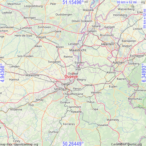
Oupeye GPS coordinates[2]
50° 42' 42.624" North, 5° 38' 48.48" East
| Map corner | latitude | longitude |
|---|---|---|
| Upper-left | 51.15496°, | 4.94368° |
| Center: | 50.71184°, | 5.6468° |
| Lower-right: | 50.26449°, | 6.34993° |
| Map W x H: | 99×99 km | = 61.5×61.5mi |
| max Lat: | 51.46791° ⇑58.1% North |
| Oupeye: | 50.71184° |
| min Lat: | ⇓41.9% South 49.53771° |
| min Long | Oupeye | max Long |
| 2.59368° | 5.6468° | 6.25749° |
| W 90.1%⇐ | ⇒9.9% E |
Elevation
Elevation of Oupeye is 125 m = 410 ft, and this is 25.5 m = 84 ft above average elevation for this country.
| Max E: |
582 m = 1909 ft | 29.4% |
| Oupeye | 125 m 410 ft | |
| Avg. | 99.5 m = 326 ft | |
Min E: |
1 m = 3 ft | 70.6% |
See also: Belgium elevation on elevation.city.
Geographical zone
Oupeye is located in North temperate zone (between Tropic of Cancer and the Arctic Circle). Distance of this North polar circle is 1762.5 km =1095.2 mi to North.| Distance of | km | miles | from Oupeye |
|---|---|---|---|
| North Pole | 4368.4 | 2714.4 | to North |
| Arctic Circle | 1762.5 | 1095.2 | to North |
| Tropic Cancer | 3032.7 | 1884.4 | to South |
| Equator | 5638.6 | 3503.7 | to South |


Nearby cities:
15 places around Oupeye: (largest is in red/bold)
• Ans
10.5 km =6.5 mi,  238°
238°
• Bassenge
5.8 km =3.6 mi,  333°
333°
• Beyne-Heusay
10 km =6.2 mi,  172°
172°
• Blégny
7 km =4.3 mi,  128°
128°
• Dalhem
5.7 km =3.5 mi,  88°
88°
• Fléron
11 km =6.8 mi, 167°
• Herstal
5.6 km =3.5 mi,  197°
197°
• Herve
13 km =8.1 mi, 127°
• Juprelle
8.1 km =5 mi,  266°
266°
• Liège
10.3 km =6.4 mi,  212°
212°
• Riemst
11.4 km =7.1 mi,  343°
343°
• Saint-Nicolas
12.3 km =7.6 mi,  220°
220°
• Sint-Pieters-Voeren
12.7 km =7.9 mi,  76°
76°
• Soumagne
13 km =8.1 mi,  147°
147°
• Visé
4.7 km =2.9 mi,  52°
52°
Sources, notices
• [Note1] Compared only with cities in Belgium existing in our database
• [Src1] Map data: © OpenStreetMap contributors (CC-BY-SA)
• [Src2] Other city data from geonames.org with taken over terms of usage.
• [Src3] Geographical zone / Annual Mean Temperature by Robert A. Rohde @ Wikipedia
