Havelange geodata
Havelange (Wallonia) is a populated place; located in Belgium in Europe/Brussels (GMT+2) time zone. With population of 4,790 people, there are 463 cities with bigger population in this country. Compared to other cities in Belgium, 85.7% of cities are located further ↑North; 74.5% of cities are located further ←West and 93% of cities have lower elevation than Havelange. Note1
Administrative division(s):
- Level 1: Wallonia
- Level 2: Province de Namur
- Level 3: Arrondissement de Dinant
- Level 4: Havelange


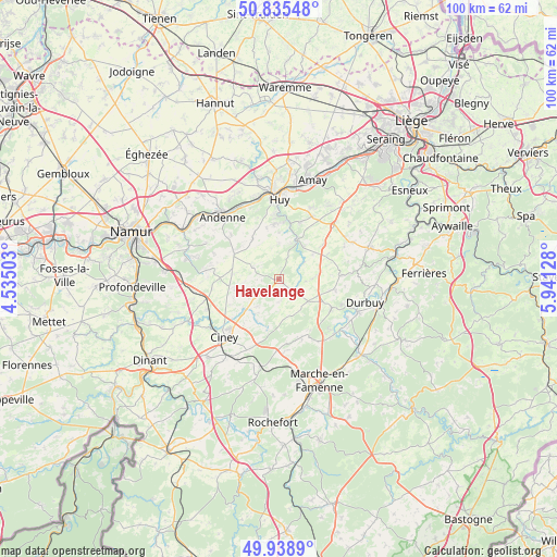
Havelange GPS coordinates[2]
50° 23' 21.516" North, 5° 14' 17.376" East
| Map corner | latitude | longitude |
|---|---|---|
| Upper-left | 50.83548°, | 4.53503° |
| Center: | 50.38931°, | 5.23816° |
| Lower-right: | 49.9389°, | 5.94128° |
| Map W x H: | 99.7×99.7 km | = 62×62mi |
| max Lat: | 51.46791° ⇑85.7% North |
| Havelange: | 50.38931° |
| min Lat: | ⇓14.3% South 49.53771° |
| min Long | Havelange | max Long |
| 2.59368° | 5.23816° | 6.25749° |
| W 74.5%⇐ | ⇒25.5% E |
Elevation
Elevation of Havelange is 303 m = 994 ft, and this is 203.5 m = 668 ft above average elevation for this country.
| Max E: |
582 m = 1909 ft | 7% |
| Havelange | 303 m 994 ft | |
| Avg. | 99.5 m = 326 ft | |
Min E: |
1 m = 3 ft | 93% |
See also: Belgium elevation on elevation.city.
Geographical zone
Havelange is located in North temperate zone (between Tropic of Cancer and the Arctic Circle). Distance of this North polar circle is 1798.4 km =1117.5 mi to North.| Distance of | km | miles | from Havelange |
|---|---|---|---|
| North Pole | 4404.3 | 2736.7 | to North |
| Arctic Circle | 1798.4 | 1117.5 | to North |
| Tropic Cancer | 2996.8 | 1862.1 | to South |
| Equator | 5602.8 | 3481.4 | to South |


Nearby cities:
15 places around Havelange: (largest is in red/bold)
• Andenne
15 km =9.3 mi,  317°
317°
• Assesse
15.5 km =9.6 mi,  261°
261°
• Ciney
14.4 km =8.9 mi,  222°
222°
• Clavier
8.1 km =5 mi,  81°
81°
• Durbuy
16 km =9.9 mi,  104°
104°
• Gesves
11.7 km =7.3 mi,  276°
276°
• Hamois
8 km =5 mi,  226°
226°
• Huy
14.4 km =8.9 mi,  358°
358°
• Marchin
8.7 km =5.4 mi,  2°
2°
• Modave
7.5 km =4.7 mi,  32°
32°
• Ohey
9.6 km =6 mi,  302°
302°
• Ouffet
17 km =10.6 mi,  71°
71°
• Somme-Leuze
10.8 km =6.7 mi,  122°
122°
• Tinlot
13.7 km =8.5 mi,  46°
46°
• Wanze
16.8 km =10.4 mi,  352°
352°
Sources, notices
• [Note1] Compared only with cities in Belgium existing in our database
• [Src1] Map data: © OpenStreetMap contributors (CC-BY-SA)
• [Src2] Other city data from geonames.org with taken over terms of usage.
• [Src3] Geographical zone / Annual Mean Temperature by Robert A. Rohde @ Wikipedia
