Mané geodata
Mané (Centre-Nord) is a seat of a third-order administrative division; located in Burkina Faso in Africa/Ouagadougou (GMT+0) time zone. In our database, there are 49 cities with bigger population. Compared to other cities in Burkina Faso, 79.7% of cities are located further ↓South; 60.8% of cities are located further ←West and 93.7% of cities have higher elevation than Mané. Note1


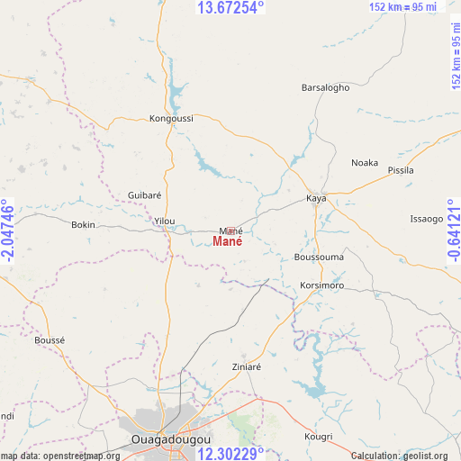
Mané GPS coordinates[2]
12° 59' 18.096" North, 1° 20' 39.624" West
| Map corner | latitude | longitude |
|---|---|---|
| Upper-left | 13.67254°, | -2.04746° |
| Center: | 12.98836°, | -1.34434° |
| Lower-right: | 12.30229°, | -0.64121° |
| Map W x H: | 152.4×152.4 km | = 94.7×94.7mi |
| max Lat: | 14.96549° ⇑20.3% North |
| Mané: | 12.98836° |
| min Lat: | ⇓79.7% South 9.88333° |
| min Long | Mané | max Long |
| -5.16667° | -1.34434° | 1.78838° |
| W 60.8%⇐ | ⇒39.2% E |
Elevation
Elevation of Mané is 258 m = 846 ft, and this is 45 m = 148 ft below average elevation for this country.
| Max E: |
423 m = 1388 ft | 93.7% |
| Avg. | 303 m = 994 ft | |
| Mané | 258 m = 846 ft | |
Min E: |
222 m = 728 ft | 6.3% |
See also: Burkina Faso elevation on elevation.city.
Geographical zone
Mané is located in North Torrid zone (between Equator and Tropic of Cancer). Distance of this Northern Tropic circle is 1161.7 km =721.8 mi to North.| Distance of | km | miles | from Mané |
|---|---|---|---|
| North Pole | 8562.9 | 5320.7 | to North |
| Arctic Circle | 5957 | 3701.5 | to North |
| Tropic Cancer | 1161.7 | 721.8 | to North |
| Equator | 1444.2 | 897.4 | to South |


Nearby cities:
15 places around Mané: (largest is in red/bold)
• Absouya
49.8 km =30.9 mi,  140°
140°
• Boussouma
29.7 km =18.5 mi,  106°
106°
• Dapélogo
41 km =25.5 mi,  211°
211°
• Kaya
30.4 km =18.9 mi,  67°
67°
• Kongoussi
42.8 km =26.6 mi,  331°
331°
• Korsimoro
35.1 km =21.8 mi,  121°
121°
• Loumbila
52.3 km =32.5 mi,  183°
183°
• Nagréongo
58.8 km =36.5 mi,  164°
164°
• Niou
68.4 km =42.5 mi,  249°
249°
• Ourgou-Manéga
29.2 km =18.1 mi,  217°
217°
• Pabré
58.2 km =36.2 mi, 206°
• Saaba
69 km =42.9 mi,  186°
186°
• Toéghin
45.8 km =28.5 mi, 245°
• Ziniaré
45.5 km =28.3 mi,  173°
173°
• Zitenga
26.9 km =16.7 mi, 172°
Sources, notices
• [Note1] Compared only with cities in Burkina Faso existing in our database
• [Src1] Map data: © OpenStreetMap contributors (CC-BY-SA)
• [Src2] Other city data from geonames.org with taken over terms of usage.
• [Src3] Geographical zone / Annual Mean Temperature by Robert A. Rohde @ Wikipedia
