Boussouma geodata
Boussouma (Centre-Nord) is a seat of a third-order administrative division; located in Burkina Faso in Africa/Ouagadougou (GMT+0) time zone. In our database, there are 49 cities with bigger population. Compared to other cities in Burkina Faso, 75.9% of cities are located further ↓South; 70.9% of cities are located further ←West and 55.7% of cities have higher elevation than Boussouma. Note1


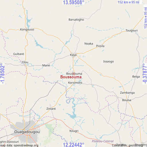
Boussouma GPS coordinates[2]
12° 54' 38.484" North, 1° 4' 54.84" West
| Map corner | latitude | longitude |
|---|---|---|
| Upper-left | 13.59508°, | -1.78502° |
| Center: | 12.91069°, | -1.0819° |
| Lower-right: | 12.22442°, | -0.37877° |
| Map W x H: | 152.4×152.4 km | = 94.7×94.7mi |
| max Lat: | 14.96549° ⇑24.1% North |
| Boussouma: | 12.91069° |
| min Lat: | ⇓75.9% South 9.88333° |
| min Long | Boussouma | max Long |
| -5.16667° | -1.0819° | 1.78838° |
| W 70.9%⇐ | ⇒29.1% E |
Elevation
Elevation of Boussouma is 301 m = 988 ft, and this is 2 m = 7 ft below average elevation for this country.
| Max E: |
423 m = 1388 ft | 55.7% |
| Avg. | 303 m = 994 ft | |
| Boussouma | 301 m = 988 ft | |
Min E: |
222 m = 728 ft | 44.3% |
See also: Burkina Faso elevation on elevation.city.
Geographical zone
Boussouma is located in North Torrid zone (between Equator and Tropic of Cancer). Distance of this Northern Tropic circle is 1170.4 km =727.3 mi to North.| Distance of | km | miles | from Boussouma |
|---|---|---|---|
| North Pole | 8571.5 | 5326.1 | to North |
| Arctic Circle | 5965.6 | 3706.9 | to North |
| Tropic Cancer | 1170.4 | 727.3 | to North |
| Equator | 1435.5 | 892 | to South |


Nearby cities:
15 places around Boussouma: (largest is in red/bold)
• Absouya
30.2 km =18.8 mi,  174°
174°
• Boulsa
61.3 km =38.1 mi,  116°
116°
• Dapélogo
56.2 km =34.9 mi,  241°
241°
• Kaya
20.1 km =12.5 mi,  359°
359°
• Kongoussi
67.3 km =41.8 mi,  313°
313°
• Korsimoro
9.7 km =6 mi, 170°
• Loumbila
53.9 km =33.5 mi,  215°
215°
• Mané
29.7 km =18.5 mi,  286°
286°
• Nagréongo
49.8 km =30.9 mi,  195°
195°
• Ourgou-Manéga
48.4 km =30.1 mi,  252°
252°
• Pabré
69.8 km =43.4 mi,  231°
231°
• Saaba
70 km =43.5 mi,  211°
211°
• Toéghin
70.8 km =44 mi,  261°
261°
• Ziniaré
43.4 km =27 mi, 212°
• Zitenga
30.6 km =19 mi, 233°
Sources, notices
• [Note1] Compared only with cities in Burkina Faso existing in our database
• [Src1] Map data: © OpenStreetMap contributors (CC-BY-SA)
• [Src2] Other city data from geonames.org with taken over terms of usage.
• [Src3] Geographical zone / Annual Mean Temperature by Robert A. Rohde @ Wikipedia
