Manga geodata
Manga (Centre-Sud) is a seat of a first-order administrative division; located in Burkina Faso in Africa/Ouagadougou (GMT+0) time zone. With population of 15,173 people, there are 29 cities with bigger population in this country. Compared to other cities in Burkina Faso, 84.8% of cities are located further ↑North; 72.2% of cities are located further ←West and 74.7% of cities have higher elevation than Manga. Note1


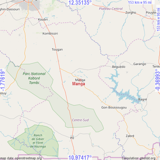
Manga GPS coordinates[2]
11° 39' 48.996" North, 1° 4' 23.016" West
| Map corner | latitude | longitude |
|---|---|---|
| Upper-left | 12.35135°, | -1.77619° |
| Center: | 11.66361°, | -1.07306° |
| Lower-right: | 10.97417°, | -0.36993° |
| Map W x H: | 153.1×153.1 km | = 95.1×95.1mi |
| max Lat: | 14.96549° ⇑84.8% North |
| Manga: | 11.66361° |
| min Lat: | ⇓15.2% South 9.88333° |
| min Long | Manga | max Long |
| -5.16667° | -1.07306° | 1.78838° |
| W 72.2%⇐ | ⇒27.8% E |
Elevation
Elevation of Manga is 286 m = 938 ft, and this is 17 m = 56 ft below average elevation for this country.
| Max E: |
423 m = 1388 ft | 74.7% |
| Avg. | 303 m = 994 ft | |
| Manga | 286 m = 938 ft | |
Min E: |
222 m = 728 ft | 25.3% |
See also: Burkina Faso elevation on elevation.city.
Geographical zone
Manga is located in North Torrid zone (between Equator and Tropic of Cancer). Distance of Equator is 1296.9 km =805.9 mi to South.| Distance of | km | miles | from Manga |
|---|---|---|---|
| North Pole | 8710.2 | 5412.3 | to North |
| Arctic Circle | 6104.3 | 3793 | to North |
| Tropic Cancer | 1309 | 813.4 | to North |
| Equator | 1296.9 | 805.9 | to South |


Nearby cities:
15 places around Manga: (largest is in red/bold)
• Gaongo
39.2 km =24.4 mi,  345°
345°
• Garango
58.9 km =36.6 mi,  75°
75°
• Kayao
92.2 km =57.3 mi,  294°
294°
• Kombissiri
53.4 km =33.2 mi,  327°
327°
• Komki-Ipala
97.1 km =60.3 mi,  306°
306°
• Komsilga
84.3 km =52.4 mi, 313°
• Koubri
69.6 km =43.2 mi, 328°
• Nagréongo
91.7 km =57 mi, 351°
• Ouagadougou
92.8 km =57.7 mi, 327°
• Pô
55.5 km =34.5 mi,  188°
188°
• Saaba
87 km =54.1 mi, 334°
• Saponé
72.3 km =44.9 mi, 306°
• Sapouy
77.3 km =48 mi,  260°
260°
• Tenkodogo
77.7 km =48.3 mi, 80°
• Zorgo
82 km =51 mi,  37°
37°
Sources, notices
• [Note1] Compared only with cities in Burkina Faso existing in our database
• [Src1] Map data: © OpenStreetMap contributors (CC-BY-SA)
• [Src2] Other city data from geonames.org with taken over terms of usage.
• [Src3] Geographical zone / Annual Mean Temperature by Robert A. Rohde @ Wikipedia
