Léo geodata
Léo (Centre-Ouest) is a seat of a second-order administrative division; located in Burkina Faso in Africa/Ouagadougou (GMT+0) time zone. With population of 26,884 people, there are 16 cities with bigger population in this country. Compared to other cities in Burkina Faso, 94.9% of cities are located further ↑North; 73.4% of cities are located further →East and 96.2% of cities have lower elevation than Léo. Note1


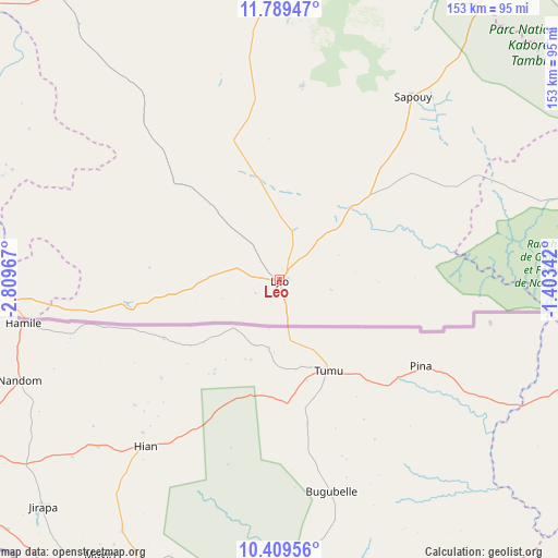
Léo GPS coordinates[2]
11° 6' 1.188" North, 2° 6' 23.544" West
| Map corner | latitude | longitude |
|---|---|---|
| Upper-left | 11.78947°, | -2.80967° |
| Center: | 11.10033°, | -2.10654° |
| Lower-right: | 10.40956°, | -1.40342° |
| Map W x H: | 153.4×153.4 km | = 95.3×95.3mi |
| max Lat: | 14.96549° ⇑94.9% North |
| Léo: | 11.10033° |
| min Lat: | ⇓5.1% South 9.88333° |
| min Long | Léo | max Long |
| -5.16667° | -2.10654° | 1.78838° |
| W 26.6%⇐ | ⇒73.4% E |
Elevation
Elevation of Léo is 349 m = 1145 ft, and this is 46 m = 151 ft above average elevation for this country.
| Max E: |
423 m = 1388 ft | 3.8% |
| Léo | 349 m 1145 ft | |
| Avg. | 303 m = 994 ft | |
Min E: |
222 m = 728 ft | 96.2% |
See also: Burkina Faso elevation on elevation.city.
Geographical zone
Léo is located in North Torrid zone (between Equator and Tropic of Cancer). Distance of Equator is 1234.2 km =766.9 mi to South.| Distance of | km | miles | from Léo |
|---|---|---|---|
| North Pole | 8772.8 | 5451.2 | to North |
| Arctic Circle | 6166.9 | 3831.9 | to North |
| Tropic Cancer | 1371.7 | 852.3 | to North |
| Equator | 1234.2 | 766.9 | to South |


Nearby cities:
15 places around Léo: (largest is in red/bold)
• Boromo
114.9 km =71.4 mi,  308°
308°
• Dano
103.9 km =64.6 mi,  272°
272°
• Diébougou
125.7 km =78.1 mi,  262°
262°
• Goulouré
127.5 km =79.2 mi,  8°
8°
• Kayao
105.5 km =65.6 mi,  15°
15°
• Kokologo
124.1 km =77.1 mi, 11°
• Kombissiri
136.5 km =84.8 mi,  37°
37°
• Komki-Ipala
125.2 km =77.8 mi, 15°
• Komsilga
131.3 km =81.6 mi, 23°
• Koudougou
131.1 km =81.5 mi,  347°
347°
• Manga
128.9 km =80.1 mi,  60°
60°
• Pitmoaga
129.7 km =80.6 mi, 10°
• Pô
105.2 km =65.4 mi,  85°
85°
• Saponé
119.2 km =74.1 mi,  27°
27°
• Sapouy
62.2 km =38.6 mi, 35°
Sources, notices
• [Note1] Compared only with cities in Burkina Faso existing in our database
• [Src1] Map data: © OpenStreetMap contributors (CC-BY-SA)
• [Src2] Other city data from geonames.org with taken over terms of usage.
• [Src3] Geographical zone / Annual Mean Temperature by Robert A. Rohde @ Wikipedia
