Gaongo geodata
Gaongo (Centre-Sud) is a seat of a third-order administrative division; located in Burkina Faso in Africa/Ouagadougou (GMT+0) time zone. In our database, there are 49 cities with bigger population. Compared to other cities in Burkina Faso, 79.7% of cities are located further ↑North; 67.1% of cities are located further ←West and 58.2% of cities have lower elevation than Gaongo. Note1


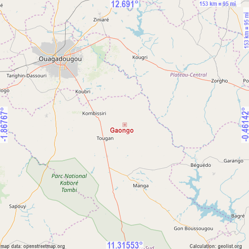
Gaongo GPS coordinates[2]
12° 0' 14.904" North, 1° 9' 52.38" West
| Map corner | latitude | longitude |
|---|---|---|
| Upper-left | 12.691°, | -1.86767° |
| Center: | 12.00414°, | -1.16455° |
| Lower-right: | 11.31553°, | -0.46142° |
| Map W x H: | 152.9×152.9 km | = 95×95mi |
| max Lat: | 14.96549° ⇑79.7% North |
| Gaongo: | 12.00414° |
| min Lat: | ⇓20.3% South 9.88333° |
| min Long | Gaongo | max Long |
| -5.16667° | -1.16455° | 1.78838° |
| W 67.1%⇐ | ⇒32.9% E |
Elevation
Elevation of Gaongo is 306 m = 1004 ft, and this is 3 m = 10 ft above average elevation for this country.
| Max E: |
423 m = 1388 ft | 41.8% |
| Gaongo | 306 m 1004 ft | |
| Avg. | 303 m = 994 ft | |
Min E: |
222 m = 728 ft | 58.2% |
See also: Burkina Faso elevation on elevation.city.
Geographical zone
Gaongo is located in North Torrid zone (between Equator and Tropic of Cancer). Distance of this Northern Tropic circle is 1271.2 km =789.9 mi to North.| Distance of | km | miles | from Gaongo |
|---|---|---|---|
| North Pole | 8672.3 | 5388.7 | to North |
| Arctic Circle | 6066.4 | 3769.5 | to North |
| Tropic Cancer | 1271.2 | 789.9 | to North |
| Equator | 1334.7 | 829.3 | to South |


Nearby cities:
15 places around Gaongo: (largest is in red/bold)
• Absouya
71.8 km =44.6 mi,  9°
9°
• Garango
70.6 km =43.9 mi,  108°
108°
• Kombissiri
20 km =12.4 mi,  291°
291°
• Komki-Ipala
71 km =44.1 mi, 286°
• Komsilga
54.9 km =34.1 mi, 291°
• Koubri
34 km =21.1 mi,  309°
309°
• Loumbila
61.5 km =38.2 mi,  338°
338°
• Manga
39.2 km =24.4 mi,  165°
165°
• Nagréongo
52.9 km =32.9 mi,  355°
355°
• Ouagadougou
56.8 km =35.3 mi,  315°
315°
• Saaba
49.1 km =30.5 mi,  326°
326°
• Saponé
48.2 km =30 mi,  276°
276°
• Tanghin-Dassouri
67.1 km =41.7 mi,  296°
296°
• Ziniaré
65.8 km =40.9 mi,  347°
347°
• Zorgo
65.6 km =40.8 mi,  65°
65°
Sources, notices
• [Note1] Compared only with cities in Burkina Faso existing in our database
• [Src1] Map data: © OpenStreetMap contributors (CC-BY-SA)
• [Src2] Other city data from geonames.org with taken over terms of usage.
• [Src3] Geographical zone / Annual Mean Temperature by Robert A. Rohde @ Wikipedia
